 Filter: Categories of Wisconsin Historical Images
Filter: FULL_DATE of 1872
Filter: Community of Milwaukee
Filter: Creator Name of Unknown
Filter: Categories of Wisconsin Historical Images
Filter: FULL_DATE of 1872
Filter: Community of Milwaukee
Filter: Creator Name of Unknown
| Date: | 1872 |
|---|---|
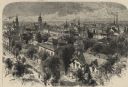
| Description: | Elevated view over residential area, with several churches in the background. |

| Date: | 1872 |
|---|---|
| Description: | This map shows wards, roads, railroads, lot and block numbers, subdivisions, parks, some landownership, and a race course. Manuscript annotations in red in... |
If you didn't find the material you searched for, our Library Reference Staff can help.
Call our reference desk at 608-264-6535 or email us at: