 Filter: Categories of Wisconsin Historical Images
Filter: FULL_DATE of 1871
Filter: Subject of roads
Filter: Categories of Wisconsin Historical Images
Filter: FULL_DATE of 1871
Filter: Subject of roads

| Date: | 1871 |
|---|---|
| Description: | Birds eye map of Brodhead, WI depicts street names and street locations, houses, and trees. A reference key at the bottom of the map shows the locations of... |

| Date: | 1871 |
|---|---|
| Description: | Birds eye map of Monroe, WI, depicts street names and street locations, houses, and trees. A reference key at the bottom of the map shows the locations of ... |

| Date: | 1871 |
|---|---|
| Description: | Birds eye map of New London depicts street names and street locations, houses, trees, the bridge, Wolf River, and the bayou. At the bottom of the map, a re... |

| Date: | 1871 |
|---|---|
| Description: | Like many southeastern Wisconsin villages, Edgerton was settled by Yankee immigrants in the 1830s. Though this view gives no indication of it, by 1871 toba... |

| Date: | 1871 |
|---|---|
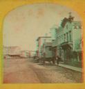
| Description: | Stereograph. In the right background is the building of the Trade Reporter newspaper at the corner of Main and High Streets; across the street from it is J... |
| Date: | 1871 |
|---|---|
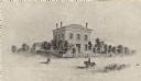
| Description: | The building has a fence around it and the yard is filled with trees. Pedestrians are in the road, as well as a man riding a horse. |
| Date: | 1871 |
|---|---|
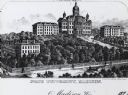
| Description: | University of Wisconsin-Madison campus. From left to right: Ladies Hall, South Dormitory, Bascom Hall, and North Dormitory. Trees are on the hill, and a f... |
| Date: | 1871 |
|---|---|
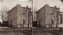
| Description: | Stereograph of exterior of a building used as the Confederate government's Executive Mansion. This was where Jefferson Davis and his family stayed during t... |

| Date: | 1871 |
|---|---|
| Description: | Stereograph. In the right background is the building of the Trade Reporter newspaper at the corner of Main and High Streets; across the street from it is J... |
| Date: | 1871 |
|---|---|
| Description: | A stereograph of the town square and Main Street. The three-story building visible in the center of the photograph was operated as the National Hotel. It w... |

| Date: | 1871 |
|---|---|
| Description: | This map of Barron County, Wisconsin, shows the township and range grid, towns, sections, cities and villages, post offices, dwellings, schools, roads, swa... |

| Date: | 1871 |
|---|---|
| Description: | This map shows buildings, roads, the railroad, an orchard, and swamp land. Relief shown by hachures. The map includes an index of buildings in the upper ri... |

| Date: | 1871 |
|---|---|
| Description: | This maps shows the entire state with an inset map in the lower left corner of Milwaukee. Railroads, roads, canals, the state capital, towns, cities, towns... |

| Date: | 1871 |
|---|---|
| Description: | This map shows the entire state, county boundaries, railroads, cities and towns, Lake Superior, and the extent of surveyed townships with Public Land Surve... |
If you didn't find the material you searched for, our Library Reference Staff can help.
Call our reference desk at 608-264-6535 or email us at:


