 Filter: Categories of Wisconsin Historical Images
Filter: FULL_DATE of 1870
Filter: Subject of transportation
Filter: County of Winnebago
Filter: Categories of Wisconsin Historical Images
Filter: FULL_DATE of 1870
Filter: Subject of transportation
Filter: County of Winnebago

| Date: | 1870 |
|---|---|
| Description: | This bird's-eye-view map shows roads, a river with boats, and homes. The bottom margin of the map includes an index. |

| Date: | 1870 |
|---|---|
| Description: | Elevated view of City Square, where the Bank of Menasha is seen on the corner and Little Lake Butte des Mortes is in the distance. |
| Date: | 1870 |
|---|---|
| Description: | Elevated view of Main Street looking east toward the Fox River and the boat landing. Lake Winnebago is in the distance. |

| Date: | 1870 |
|---|---|
| Description: | The corner of unpaved Main Street and Tayco Street looking south towards Doty Island. The slanting timbers controlled the primitive draw bridge across the ... |

| Date: | 1870 |
|---|---|
| Description: | The National Hotel on town square off of Main Street. A group of people and horse-drawn vehicles are in front of the hotel. |
| Date: | 1870 |
|---|---|
| Description: | Stereograph view of Cedar Street Bridge(?) with a rocky shoreline on the left. The construction of this bridge is the same as the Cedar Street bridge, but ... |
| Date: | 1870 |
|---|---|
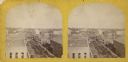
| Description: | Stereograph view of the flour mill district. The Cedar Street Bridge is in the background, and the mills are, right to left going back, the Winnebago Flour... |

| Date: | 1870 |
|---|---|
| Description: | Stereograph of flour mill district. The Walnut Street bridge is in the background and the mill to the right is the Atlantic Mills (Neenah Stone Mills in 18... |
| Date: | 1870 |
|---|---|
| Description: | Stereograph of an elevated view of Cedar Street, north side. |
| Date: | 1870 |
|---|---|
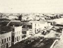
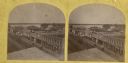
| Description: | Stereograph of an elevated view of the business district. |

| Date: | 1870 |
|---|---|
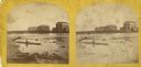
| Description: | Stereograph of a view along the Fox River. A pier with pilings is along the right, with industrial buildings. |

| Date: | 1870 |
|---|---|
| Description: | Stereograph of Main Street viewed from the bridge. The Revere House is just beyond the bridge on the right, and on the left is a sign on the side of a buil... |

| Date: | 1870 |
|---|---|
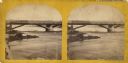
| Description: | Stereograph of an elevated view of the Main Street bridge, looking toward a section of the city known locally as Brooklyn. |

| Date: | 1870 |
|---|---|
| Description: | Stereograph of Main Street bridge, looking toward a section of the city known locally as Brooklyn. |
If you didn't find the material you searched for, our Library Reference Staff can help.
Call our reference desk at 608-264-6535 or email us at:

