 Filter: Categories of Wisconsin Historical Images
Filter: FULL_DATE of 1870
Filter: Subject of streets
Filter: Categories of Wisconsin Historical Images
Filter: FULL_DATE of 1870
Filter: Subject of streets
| Date: | 1870 |
|---|---|
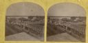
| Description: | Stereograph of an elevated view of the business district. |
| Date: | 1870 |
|---|---|
| Description: | Dousman Warehouse, East Water Street. Originally located on the wharf parallel with the river. Built and used by George and Talbot, brothers of Hercules Do... |

| Date: | 1870 |
|---|---|
| Description: | Stereograph of Main Street viewed from the bridge. The Revere House is just beyond the bridge on the right, and on the left is a sign on the side of a buil... |

| Date: | 1870 |
|---|---|
| Description: | Stereograph of an elevated view of the Main Street bridge, looking toward a section of the city known locally as Brooklyn. |
| Date: | 1870 |
|---|---|
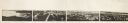
| Description: | Panoramic view of Madison, taken from the roof of South Hall. This reduced copy was made from original negatives by E.C. Nielson. Labels for both Lake Mend... |
| Date: | 1870 |
|---|---|
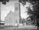
| Description: | View across street toward the exterior of Immanuel's Kirche dur Evangelical German church. All the arched windows are decorated with stained glass, mostly ... |

| Date: | 1870 |
|---|---|
| Description: | Stereograph looking south from the post office at the corner of Mifflin Street and Wisconsin Avenue across one corner of the Capitol Square toward Grace Ep... |
| Date: | 1870 |
|---|---|
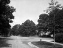
| Description: | A view of an intersection of tree-lined streets in a residential area. Homes are partially visible on the right. |

| Date: | 1870 |
|---|---|
| Description: | A view of a tree-lined residential street, with homes partially visible on the right. |

| Date: | 1870 |
|---|---|
| Description: | Bird’s-eye view map. "Looking north east." Indexed for points of interest. Shows homes, businesses, and the Bark and Rock River. Streets running west to ea... |
| Date: | 1870 |
|---|---|
| Description: | Stereograph view of Oconomowoc. |

| Date: | 1870 |
|---|---|
| Description: | This map of the Village of North La Crosse is partially hand-drawn and includes text about the land in the lower margin. |

| Date: | 1870 |
|---|---|
| Description: | This blueprint map shows lot and block numbers, streets, and right of way for the Two Rivers Branch railroad. The map covers land west to sections 22 and 2... |

| Date: | 1870 |
|---|---|
| Description: | This blue line print covers the stretch of railroad numbered 1478+40 through 1689+60. Some streets and blocks in the town and the Wolf River are labeled. |

| Date: | 1870 |
|---|---|
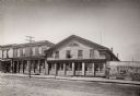
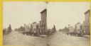
| Description: | Elevated view of an unpaved main street, with the Village House across the street in the center background. Wooden buildings and wooden sidewalks are on bo... |
If you didn't find the material you searched for, our Library Reference Staff can help.
Call our reference desk at 608-264-6535 or email us at:
