Filter: Categories of Wisconsin Historical Images
Filter: FULL_DATE of 1870
Filter: Subject of streets
Filter: Categories of Wisconsin Historical Images
Filter: FULL_DATE of 1870
Filter: Subject of streets

| Date: | 1870 |
|---|---|
| Description: | This bird's-eye-view map shows roads, a river with boats, and homes. The bottom margin of the map includes an index. |

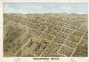
| Date: | 1870 |
|---|---|
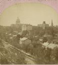
| Description: | Bird's-eye view of Whitewater, with insets. |
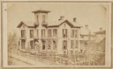
| Date: | 1870 |
|---|---|
| Description: | Elevated view of the Robert M. Bashford house on Pinckney and Gilman Streets. A man wearing a hat stands in the landscaped yard near a small child wearing ... |
| Date: | 1870 |
|---|---|
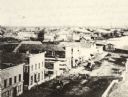
| Description: | Elevated view of Main Street and Green Bay House seen from the top of the Beaumont House. |
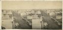
| Date: | 1870 |
|---|---|
| Description: | Elevated view looking down Court Street in Janesville toward the west. |

| Date: | 1870 |
|---|---|
| Description: | Elevated view over river of Dodge Street in Janesville looking west. |

| Date: | 1870 |
|---|---|
| Description: | Elevated view of the busy streets of Court and Milwaukee. Three prominent buildings in view are: Court Street Methodist Church on the far left (b. 1868), w... |

| Date: | 1870 |
|---|---|
| Description: | View from along right side of bridge of Milwaukee Street looking east in Janesville. The Myers House is located at the top of the hill. There is a sign for... |

| Date: | 1870 |
|---|---|
| Description: | View across intersection towards Kimball's Hall, one of the first brick buildings in Kenosha. A sign on the right side of the building reads: "Dewey & Sinc... |
| Date: | 1870 |
|---|---|
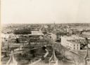
| Description: | Elevated view toward the Capitol Square from Pinckney and Gorham Streets. |
| Date: | 1870 |
|---|---|
| Description: | The Flom Hotel or American House, 323 East Main Street, at the corner of South Hancock Street. The Vilas House, whose conveyance stands in front, was a riv... |

| Date: | 1870 |
|---|---|
| Description: | Slightly elevated view of the Lindon House. Two women are standing on the second floor front balcony. |

| Date: | 1870 |
|---|---|
| Description: | Elevated view of City Square, where the Bank of Menasha is seen on the corner and Little Lake Butte des Mortes is in the distance. |
| Date: | 1870 |
|---|---|
| Description: | Elevated view of Main Street looking east toward the Fox River and the boat landing. Lake Winnebago is in the distance. |

| Date: | 1870 |
|---|---|
| Description: | The corner of unpaved Main Street and Tayco Street looking south towards Doty Island. The slanting timbers controlled the primitive draw bridge across the ... |

| Date: | 1870 |
|---|---|
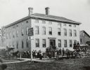
| Description: | The National Hotel on town square off of Main Street. A group of people and horse-drawn vehicles are in front of the hotel. |
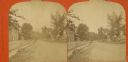
| Date: | 1870 |
|---|---|
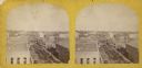
| Description: | Stereograph of an elevated view of Cedar Street, north side. |
If you didn't find the material you searched for, our Library Reference Staff can help.
Call our reference desk at 608-264-6535 or email us at: