 Filter: Categories of Wisconsin Historical Images
Filter: FULL_DATE of 1870
Filter: Subject of service industries
Filter: Subject of roads
Filter: Categories of Wisconsin Historical Images
Filter: FULL_DATE of 1870
Filter: Subject of service industries
Filter: Subject of roads
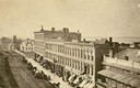
| Date: | 1870 |
|---|---|
| Description: | View overlooking Pinckney Street on the Square with the American Hotel in the background. |
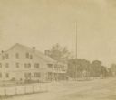
| Date: | 1870 |
|---|---|
| Description: | View down road towards the Western Hotel on the left. The original tavern was built in 1834 (?) by William Shields (?). In 1845 it was operated by his son ... |
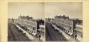
| Date: | 1870 |
|---|---|
| Description: | View overlooking Pinckney Street on the Square with the American Hotel in the background. |

| Date: | 1870 |
|---|---|
| Description: | A map of Iowa County, Wisconsin mounted on cloth that shows the villages of Avoca, Mifflin, Linden, Arena, Helena Station, Highland, Dodgeville, as well as... |

| Date: | 1870 |
|---|---|
| Description: | This 1870 map of Brown County, Wisconsin, shows the township and range grid, towns, sections, cities, villages and post offices, land ownership, roads, rai... |

| Date: | 1870 |
|---|---|
| Description: | This map is ink and color on tracing cloth and shows Iron Ridge, the hotel and saw mill at Iron Ridge Village, Milwaukee & St. Paul Railway, plank road, an... |
If you didn't find the material you searched for, our Library Reference Staff can help.
Call our reference desk at 608-264-6535 or email us at: