 Filter: Categories of Wisconsin Historical Images
Filter: FULL_DATE of 1870
Filter: Subject of schools
Filter: Categories of Wisconsin Historical Images
Filter: FULL_DATE of 1870
Filter: Subject of schools
| Date: | 1870 |
|---|---|
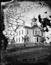
| Description: | Two-story brick building built in 1870 with arched windows, corner brackets, bell tower with elaborate cut work, four chimneys and fence in front. Inscript... |
| Date: | 1870 |
|---|---|
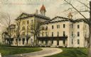
| Description: | The State Institute for the Blind, a school free for blind children of Wisconsin. Caption reads: "State Institute for Blind, Janesville, Wis." |
| Date: | 1870 |
|---|---|
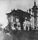
| Description: | State Normal School. A group of men are standing in the tall grass in the left foreground. |

| Date: | 1870 |
|---|---|
| Description: | A map of Iowa County, Wisconsin mounted on cloth that shows the villages of Avoca, Mifflin, Linden, Arena, Helena Station, Highland, Dodgeville, as well as... |

| Date: | 1870 |
|---|---|
| Description: | This 1870 map of Brown County, Wisconsin, shows the township and range grid, towns, sections, cities, villages and post offices, land ownership, roads, rai... |
If you didn't find the material you searched for, our Library Reference Staff can help.
Call our reference desk at 608-264-6535 or email us at:
