 Filter: Categories of Wisconsin Historical Images
Filter: FULL_DATE of 1870
Filter: Subject of rivers
Filter: Categories of Wisconsin Historical Images
Filter: FULL_DATE of 1870
Filter: Subject of rivers
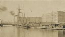
| Date: | 1870 |
|---|---|
| Description: | North of Huron Street Bridge looking toward point near Grand Avenue crossing. A ship with several masts is docked on the river, and several large building... |
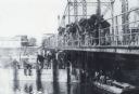
| Date: | 1870 |
|---|---|
| Description: | A large group of men are snagging sturgeon from a bridge over the Wolf River. A sturgeon is hanging from a line. More men are sitting on a bridge support, ... |

| Date: | 1870 |
|---|---|
| Description: | View across water toward the back side of a railroad station and outbuilding that face the creek. A hotel, garage, and homes are around the structure. |
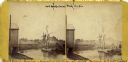
| Date: | 1870 |
|---|---|
| Description: | View of a lumber hooker ship at dock on the Root River. The 4th St. bridge spans the river at center. The Racine Woolen Mill is visible at right behind the... |
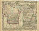
| Date: | 1870 |
|---|---|
| Description: | A hand-colored map of Wisconsin and Michigan detailing the states’ rivers, lakes, counties, town and cities. The map gives the greatest length, breadth, me... |

| Date: | 1870 |
|---|---|
| Description: | A geological survey map of Wisconsin, with hand-colored portions showing the surveys completed from 1873 to 1875. Although the title and legend are in Wel... |

| Date: | 1870 |
|---|---|
| Description: | Map of Wisconsin showing counties and their county seats, towns and cities with over 3,000 inhabitants, the Detroit and Milwaukee Steam Ship Line, and both... |

| Date: | 1870 |
|---|---|
| Description: | Bird’s-eye view map. "Looking north east." Indexed for points of interest. Shows homes, businesses, and the Bark and Rock River. Streets running west to ea... |

| Date: | 1870 |
|---|---|
| Description: | This blueprint map shows lot and block numbers, streets, and right of way for the Two Rivers Branch railroad. The map covers land west to sections 22 and 2... |

| Date: | 1870 |
|---|---|
| Description: | This blue line print covers the stretch of railroad numbered 1478+40 through 1689+60. Some streets and blocks in the town and the Wolf River are labeled. |
If you didn't find the material you searched for, our Library Reference Staff can help.
Call our reference desk at 608-264-6535 or email us at: