 Filter: Categories of Wisconsin Historical Images
Filter: FULL_DATE of 1870
Filter: Subject of rivers
Filter: Subject of transportation
Filter: Categories of Wisconsin Historical Images
Filter: FULL_DATE of 1870
Filter: Subject of rivers
Filter: Subject of transportation

| Date: | 1870 |
|---|---|
| Description: | This bird's-eye-view map shows roads, a river with boats, and homes. The bottom margin of the map includes an index. |
| Date: | 1870 |
|---|---|
| Description: | The sidewheel steam rafter "Clyde," which was the first iron hull steamboat. Sign on side of boat reads: "Dubuque, Reads Landing & Eau Claire." Agricultura... |

| Date: | 1870 |
|---|---|
| Description: | During the War of 1812, the only battle fought in Wisconsin was in Prairie du Chien, in 1814. Made fifty-six years later, this birds eye drawing depicts th... |
| Date: | 1870 |
|---|---|
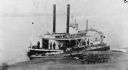
| Description: | The sternwheel packet, Arkansas, loaded with gunny sacks of wheat taken between 1872 and 1878. Men are unloading barrels and gunny sacks on a gangpl... |
| Date: | 1870 |
|---|---|
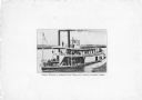
| Description: | The sternwheel excursion, Minnieta, on the Chippewa River, Wisconsin, in the 1870's. |

| Date: | 1870 |
|---|---|
| Description: | Baraboo was first settled around 1838, and by 1870 it had become the county seat and the thriving village illustrated here. This birds eye drawing depicts ... |

| Date: | 1870 |
|---|---|
| Description: | Bird's-eye map of Hudson, with insets of Court House and Public School. |

| Date: | 1870 |
|---|---|
| Description: | Although the first European settlement in Jefferson was in 1836, the Village of Jefferson was first incorporated as a city in 1878. Made eight years earlie... |

| Date: | 1870 |
|---|---|
| Description: | Bird's-eye map of Kilbourn City, now known as Wisconsin Dells. Kilbourn City was platted in the 1850s and received a boost when the La Crosse and Milwaukee... |

| Date: | 1870 |
|---|---|
| Description: | Bird's-eye view of Whitewater, with insets. |
| Date: | 1870 |
|---|---|
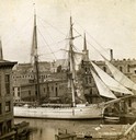
| Description: | Elevated view of Milwaukee River with large sailing ship - a two-masted schooner - entering the port. |
| Date: | 1870 |
|---|---|
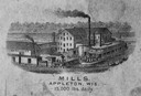
| Description: | Sketch of the Fox River, a train, the mill, a warehouse, and a steamboat. |
| Date: | 1870 |
|---|---|
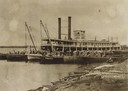
| Description: | View of the town and Chippewa river, with a steamboat in the center along the riverbank. A smaller boat is next to the steamboat, with a man standing eithe... |

| Date: | 1870 |
|---|---|
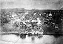
| Description: | Five piece panoramic view of the Green Bay waterfront area. |

| Date: | 1870 |
|---|---|
| Description: | Elevated view over river of Dodge Street in Janesville looking west. |
| Date: | 1870 |
|---|---|
| Description: | View across water towards the Habheger's Bowling Park at the North Fourth Street bridge. A group of people are standing on the bridge. |

| Date: | 1870 |
|---|---|
| Description: | The corner of unpaved Main Street and Tayco Street looking south towards Doty Island. The slanting timbers controlled the primitive draw bridge across the ... |
If you didn't find the material you searched for, our Library Reference Staff can help.
Call our reference desk at 608-264-6535 or email us at:


