 Filter: Categories of Wisconsin Historical Images
Filter: FULL_DATE of 1870
Filter: Subject of mississippi river
Filter: Categories of Wisconsin Historical Images
Filter: FULL_DATE of 1870
Filter: Subject of mississippi river

| Date: | 1870 |
|---|---|
| Description: | During the War of 1812, the only battle fought in Wisconsin was in Prairie du Chien, in 1814. Made fifty-six years later, this birds eye drawing depicts th... |
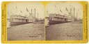
| Date: | 1870 |
|---|---|
| Description: | The sternwheel packet, Red Wing, at a landing on the upper Mississippi River between 1870 and 1882. The sign painted over the wheel reads: "Keokuk N... |

| Date: | 1870 |
|---|---|
| Description: | Half stereograph of an elevated view from hill showing the confluence of the Mississippi River and the St. Croix River. A man wearing a hat is in the foreg... |
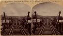
| Date: | 1870 |
|---|---|
| Description: | Stereograph of John Lawler's pile-pontoon railway bridge over the Mississippi River. Three men are standing and sitting on the bridge in the foreground. Bu... |

| Date: | 1870 |
|---|---|
| Description: | Stereograph of John Lawler's pile-pontoon railway bridge over the Mississippi River. |

| Date: | 1870 |
|---|---|
| Description: | A geological survey map of Wisconsin, with hand-colored portions showing the surveys completed from 1873 to 1875. Although the title and legend are in Wel... |

| Date: | 1870 |
|---|---|
| Description: | This map is mostly pencil on paper map but includes latitude and longitude grid in ink. The map covers the Mississippi River from Lake Itasca to the Wiscon... |
If you didn't find the material you searched for, our Library Reference Staff can help.
Call our reference desk at 608-264-6535 or email us at: