 Filter: Categories of Wisconsin Historical Images
Filter: FULL_DATE of 1870
Filter: Subject of michigan, lake
Filter: Categories of Wisconsin Historical Images
Filter: FULL_DATE of 1870
Filter: Subject of michigan, lake
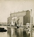
| Date: | 1870 |
|---|---|
| Description: | The Milwaukee & St. Paul Railway Company grain elevator at the Milwaukee harbor, with a sailing ship anchored nearby. |
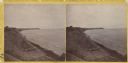
| Date: | 1870 |
|---|---|
| Description: | Stereograph; looking north from the end of Oneida Street along shoreline. |

| Date: | 1870 |
|---|---|
| Description: | Water tower of the Milwaukee water works, North Point. |
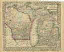
| Date: | 1870 |
|---|---|
| Description: | A hand-colored map of Wisconsin and Michigan detailing the states’ rivers, lakes, counties, town and cities. The map gives the greatest length, breadth, me... |

| Date: | 1870 |
|---|---|
| Description: | A geological survey map of Wisconsin, with hand-colored portions showing the surveys completed from 1873 to 1875. Although the title and legend are in Wel... |

| Date: | 1870 |
|---|---|
| Description: | Map of Wisconsin showing counties and their county seats, towns and cities with over 3,000 inhabitants, the Detroit and Milwaukee Steam Ship Line, and both... |

| Date: | 1870 |
|---|---|
| Description: | This blueprint map shows lot and block numbers, streets, and right of way for the Two Rivers Branch railroad. The map covers land west to sections 22 and 2... |
If you didn't find the material you searched for, our Library Reference Staff can help.
Call our reference desk at 608-264-6535 or email us at: