 Filter: Categories of Wisconsin Historical Images
Filter: FULL_DATE of 1870
Filter: Subject of land
Filter: Categories of Wisconsin Historical Images
Filter: FULL_DATE of 1870
Filter: Subject of land

| Date: | 1870 |
|---|---|
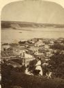
| Description: | Elevated view of the town, looking northwest. The Chippewa River is in the foreground, with a lot of buildings, an intersection, and distant hills. One bui... |
| Date: | 1870 |
|---|---|
| Description: | View of Hudson with three women on a hill in the foreground, and the town along the St. Croix River below in the background. |

| Date: | 1870 |
|---|---|
| Description: | Stereograph of Lodi, Wisconsin. A field is in the foreground, and the town beyond and hills in the far background. |
| Date: | 1870 |
|---|---|
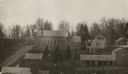
| Description: | View over rooftops towards the primitive Methodist Church, which is surrounded by homes. |
| Date: | 1870 |
|---|---|
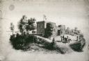
| Description: | Benjamin Walker Castle, 1862-1893, 900 block East Gorham Street. There are two deer are the left near trees, and two people are on horseback near the front... |

| Date: | 1870 |
|---|---|
| Description: | Wisconsin State Hospital for the Insane (Mendota Mental Health Institute). |

| Date: | 1870 |
|---|---|
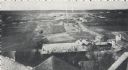
| Description: | Half stereograph of an elevated view from hill showing the confluence of the Mississippi River and the St. Croix River. A man wearing a hat is in the foreg... |
| Date: | 1870 |
|---|---|
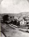
| Description: | One-half stereograph of town, elevated view looking northeast from Case's Block. |
| Date: | 1870 |
|---|---|
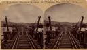
| Description: | Stereograph of John Lawler's pile-pontoon railway bridge over the Mississippi River. Three men are standing and sitting on the bridge in the foreground. Bu... |
| Date: | 1870 |
|---|---|
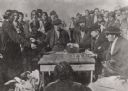
| Description: | Indians receiving payment. Seated on the right is John W. Bell. Others are, left to right, Asaph Whittlesey, Agent Henry C. Gilbert, and William S. Warren ... |

| Date: | 1870 |
|---|---|
| Description: | Slightly elevated view at an angle towards the left and front of the courthouse. A large statue is on top of the main dome. The area around the courthouse ... |
| Date: | 1870 |
|---|---|
| Description: | Stereograph; looking north from the end of Oneida Street along shoreline. |
| Date: | 1870 |
|---|---|
| Description: | Elevated view from rooftops of what was known as Watertown Plank road, looking west from about North 35th Street. Several homes, and many open fields occup... |

| Date: | 1870 |
|---|---|
| Description: | View from shore of sailboat anchored on the lake. There appears to be an island in the upper left. |

| Date: | 1870 |
|---|---|
| Description: | View of two lakeside cottage, which have docks and porches that overlook the lake. Caption reads: "Birch Walk, Kelly Lake, Wis." |

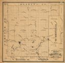
| Date: | 1870 |
|---|---|
| Description: | This 1870 map of Brown County, Wisconsin, shows the township and range grid, towns, sections, cities, villages and post offices, land ownership, roads, rai... |
| Date: | 1870 |
|---|---|
| Description: | This 1870 map of Waupaca County, Wisconsin, shows the township and range grid, towns, cities and villages, and lakes and streams. |
If you didn't find the material you searched for, our Library Reference Staff can help.
Call our reference desk at 608-264-6535 or email us at:


