 Filter: Categories of Wisconsin Historical Images
Filter: FULL_DATE of 1870
Filter: Subject of human settlements
Filter: Categories of Wisconsin Historical Images
Filter: FULL_DATE of 1870
Filter: Subject of human settlements

| Date: | 1870 |
|---|---|
| Description: | This 1870 map of Brown County, Wisconsin, shows the township and range grid, towns, sections, cities, villages and post offices, land ownership, roads, rai... |
| Date: | 1870 |
|---|---|
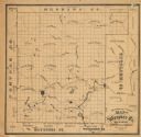
| Description: | This 1870 map of Waupaca County, Wisconsin, shows the township and range grid, towns, cities and villages, and lakes and streams. |

| Date: | 1870 |
|---|---|
| Description: | Bird’s-eye view map. "Looking north east." Indexed for points of interest. Shows homes, businesses, and the Bark and Rock River. Streets running west to ea... |
| Date: | 1870 |
|---|---|
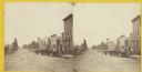
| Description: | Stereograph view of Oconomowoc. |

| Date: | 1870 |
|---|---|
| Description: | Section of overall panorama, showing railroad station. |

| Date: | 1870 |
|---|---|
| Description: | This map of the Village of North La Crosse is partially hand-drawn and includes text about the land in the lower margin. |
| Date: | 1870 |
|---|---|
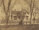
| Description: | View across road of the Clough house, residence of Mr. and Mrs. Willoughby. A man is standing and holding the hands of two young girls in front of the fenc... |
| Date: | 1870 |
|---|---|
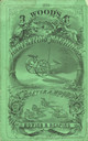
| Description: | Front cover of catalog with a green cover for Wood's harvesting machines. Features an illustration of, at the top, a view of a town, flanked by two women, ... |

| Date: | 1870 |
|---|---|
| Description: | View across water towards where brothers John and August Lindstrom had a pop factory at 409 N. Blair Street during the 1870s and 1880s. They lived above th... |

| Date: | 1870 |
|---|---|
| Description: | Exterior view from street of the 420 N. Carroll Street home of J.R. Mears, built in 1870. The Italianate-style house is on the corner of W. Gilman and N. C... |

| Date: | 1870 |
|---|---|
| Description: | This blueprint map shows lot and block numbers, streets, and right of way for the Two Rivers Branch railroad. The map covers land west to sections 22 and 2... |

| Date: | 1870 |
|---|---|
| Description: | This blue line print covers the stretch of railroad numbered 1478+40 through 1689+60. Some streets and blocks in the town and the Wolf River are labeled. |
| Date: | 1870 |
|---|---|
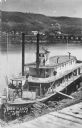
| Description: | Elevated view of the steamer Ellen Hardy at dock. Text on the bottom left reads: "'Ellen Hardy' at Pr-Du-Sac. in 1870." The Ellen Hardy belo... |

| Date: | 1870 |
|---|---|
| Description: | Detail from original of the family. Original caption reads: "Norwegian family posing with their household possessions, in front of their home. The man dres... |

| Date: | 1870 |
|---|---|
| Description: | Elevated view of an unpaved main street, with the Village House across the street in the center background. Wooden buildings and wooden sidewalks are on bo... |
If you didn't find the material you searched for, our Library Reference Staff can help.
Call our reference desk at 608-264-6535 or email us at: