 Filter: Categories of Wisconsin Historical Images
Filter: FULL_DATE of 1870
Filter: Subject of education
Filter: Subject of cities and towns
Filter: Categories of Wisconsin Historical Images
Filter: FULL_DATE of 1870
Filter: Subject of education
Filter: Subject of cities and towns

| Date: | 1870 |
|---|---|
| Description: | Baraboo was first settled around 1838, and by 1870 it had become the county seat and the thriving village illustrated here. This birds eye drawing depicts ... |

| Date: | 1870 |
|---|---|
| Description: | Bird's-eye map of Hudson, with insets of Court House and Public School. |
| Date: | 1870 |
|---|---|
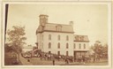
| Description: | View of Baraboo high school with a large group of students standing around it. |
| Date: | 1870 |
|---|---|
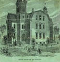
| Description: | View of the Berlin High School, with children playing and people walking in the foreground. |

| Date: | 1870 |
|---|---|
| Description: | Third Ward, East Side, or "Bartlett School." This is probably the earliest picture in existence and is copied form the margin of "an old map." This first... |

| Date: | 1870 |
|---|---|
| Description: | Elevated view of the town, looking northwest. The Chippewa River is in the foreground, with a lot of buildings, an intersection, and distant hills. One bui... |
| Date: | 1870 |
|---|---|
| Description: | The State Institute for the Blind, a school free for blind children of Wisconsin. Caption reads: "State Institute for Blind, Janesville, Wis." |
| Date: | 1870 |
|---|---|
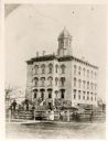
| Description: | Jefferson School, built on the site of the first cemetery in Janesville. |
| Date: | 1870 |
|---|---|
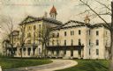
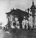
| Description: | State Normal School. A group of men are standing in the tall grass in the left foreground. |
| Date: | 1870 |
|---|---|
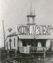
| Description: | In 1844 Joseph Goodrich founded Milton Academy and built the first gravel and mortar building in the town. (Note that the Milton House is often called the ... |

| Date: | 1870 |
|---|---|
| Description: | View toward front and right side of the Lincoln School, partially obscured by trees. The roof line features dormers and two towers. Caption reads: "Lincoln... |

| Date: | 1870 |
|---|---|
| Description: | A map of Iowa County, Wisconsin mounted on cloth that shows the villages of Avoca, Mifflin, Linden, Arena, Helena Station, Highland, Dodgeville, as well as... |

| Date: | 1870 |
|---|---|
| Description: | This 1870 map of Brown County, Wisconsin, shows the township and range grid, towns, sections, cities, villages and post offices, land ownership, roads, rai... |
If you didn't find the material you searched for, our Library Reference Staff can help.
Call our reference desk at 608-264-6535 or email us at:
