Filter: Categories of Wisconsin Historical Images
Filter: FULL_DATE of 1870
Filter: Creator Name of Unknown
Filter: Subject of water
Filter: Categories of Wisconsin Historical Images
Filter: FULL_DATE of 1870
Filter: Creator Name of Unknown
Filter: Subject of water
| Date: | 1870 |
|---|---|
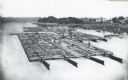
| Description: | Elevated view of lumber raft and workers on the Chippewa River. In the background on the right are dwellings. |
| Date: | 1870 |
|---|---|
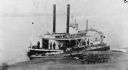
| Description: | The sidewheel steam rafter "Clyde," which was the first iron hull steamboat. Sign on side of boat reads: "Dubuque, Reads Landing & Eau Claire." Agricultura... |
| Date: | 1870 |
|---|---|
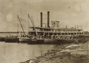
| Description: | The sternwheel packet, Arkansas, loaded with gunny sacks of wheat taken between 1872 and 1878. Men are unloading barrels and gunny sacks on a gangpl... |
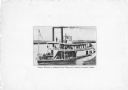
| Date: | 1870 |
|---|---|
| Description: | The sternwheel excursion, Minnieta, on the Chippewa River, Wisconsin, in the 1870's. |

| Date: | 1870 |
|---|---|
| Description: | Bird's-eye map of Madison. The Lakeside House resort is in the foreground, which burned in 1877, in what is now Olin Park. |
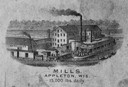
| Date: | 1870 |
|---|---|
| Description: | Sketch of the Fox River, a train, the mill, a warehouse, and a steamboat. |

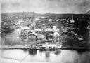
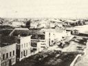
| Date: | 1870 |
|---|---|
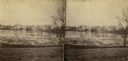
| Description: | Elevated view of the town, looking northwest. The Chippewa River is in the foreground, with a lot of buildings, an intersection, and distant hills. One bui... |
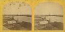
| Date: | 1870 |
|---|---|
| Description: | View of the town and Chippewa river, with a steamboat in the center along the riverbank. A smaller boat is next to the steamboat, with a man standing eithe... |

| Date: | 1870 |
|---|---|
| Description: | Elevated view over river of Dodge Street in Janesville looking west. |
| Date: | 1870 |
|---|---|
| Description: | View across water towards the Habheger's Bowling Park at the North Fourth Street bridge. A group of people are standing on the bridge. |

| Date: | 1870 |
|---|---|
| Description: | Elevated view of City Square, where the Bank of Menasha is seen on the corner and Little Lake Butte des Mortes is in the distance. |
| Date: | 1870 |
|---|---|
| Description: | Elevated view of Main Street looking east toward the Fox River and the boat landing. Lake Winnebago is in the distance. |

| Date: | 1870 |
|---|---|
| Description: | The corner of unpaved Main Street and Tayco Street looking south towards Doty Island. The slanting timbers controlled the primitive draw bridge across the ... |
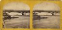
| Date: | 1870 |
|---|---|
| Description: | Stereograph view of Cedar Street Bridge(?) with a rocky shoreline on the left. The construction of this bridge is the same as the Cedar Street bridge, but ... |
| Date: | 1870 |
|---|---|
| Description: | Stereograph of an elevated view of the lumbering industry on the Fox River. Lake Winnebago is in the background. |

| Date: | 1870 |
|---|---|
| Description: | Stereograph of a view along the Fox River. A pier with pilings is along the right, with industrial buildings. |

| Date: | 1870 |
|---|---|
| Description: | Stereograph of an elevated view of the Main Street bridge, looking toward a section of the city known locally as Brooklyn. |

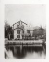
| Date: | 1870 |
|---|---|
| Description: | Axtell House, located at Walker's point on the corner of S. Water and Ferry Streets. There are pedestrians on the bridge over the river. |
If you didn't find the material you searched for, our Library Reference Staff can help.
Call our reference desk at 608-264-6535 or email us at: