 Filter: Categories of Wisconsin Historical Images
Filter: FULL_DATE of 1869
Filter: Subject of railroads
Filter: Categories of Wisconsin Historical Images
Filter: FULL_DATE of 1869
Filter: Subject of railroads
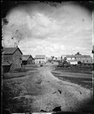
| Date: | 1869 |
|---|---|
| Description: | View from across the railroad track. The Milwaukee and St. Paul Railroad car #4770 is in the foreground. The Freeman House, Carlisle House and Empire Stove... |
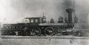
| Date: | 1869 |
|---|---|
| Description: | Milwaukee and St. Paul Railway locomotive no. 40, called the L.B. Rock, at the Chestnut Street yards. The mast of a ship is visible in the background, and ... |

| Date: | 1869 |
|---|---|
| Description: | This geological map shows the township grid, counties, cities and villages, rivers, lakes, railroads, and roads. Barron County is still labeled Dallas Coun... |

| Date: | 1869 |
|---|---|
| Description: | This map shows lot and block numbers, some property ownership, wards, roads, and railroads and includes inset map of Glidden & Lockwood’s addition. There a... |
If you didn't find the material you searched for, our Library Reference Staff can help.
Call our reference desk at 608-264-6535 or email us at: