 Filter: Categories of Wisconsin Historical Images
Filter: FULL_DATE of 1869
Filter: Subject of land
Filter: Categories of Wisconsin Historical Images
Filter: FULL_DATE of 1869
Filter: Subject of land
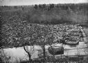
| Date: | 1869 |
|---|---|
| Description: | Elevated view from steep shoreline of a log jam of about 150 million feet of logs, stopped at the piers of Pound, Halbert, and Co., which stood in about 40... |

| Date: | 1869 |
|---|---|
| Description: | Birds-eye drawing of Boscobel, Grant County, depicts street names and street layouts, houses, rivers and trees. A reference key at the bottom of the map sh... |
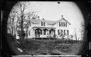
| Date: | 1869 |
|---|---|
| Description: | Two men standing and three women sitting on porch that has carpenter's lace trim; frame house with gable and window and latticework at bottom of porch. A d... |

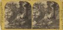
| Date: | 1869 |
|---|---|
| Description: | Increase A. Lapham in the foreground of a rock formation in Taylor's Glen, with A. Holly sitting on a rock in the background. |
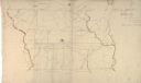
| Date: | 1869 |
|---|---|
| Description: | Hand-drawn map of York County, South Carolina. |

| Date: | 1869 |
|---|---|
| Description: | This geological map shows the township grid, counties, cities and villages, rivers, lakes, railroads, and roads. Barron County is still labeled Dallas Coun... |
| Date: | 1869 |
|---|---|
| Description: | Two girls in long dresses on a rock formation. The river and far shoreline is in the background. Text on left reads: "A Visit to Devil's Lake, Sauk County,... |

| Date: | 1869 |
|---|---|
| Description: | Map shows townships and sections, landownership and acreages, buildings, and marshes. The map includes insets of Franklin, Hales Corners, Bay View, Oak Cre... |
If you didn't find the material you searched for, our Library Reference Staff can help.
Call our reference desk at 608-264-6535 or email us at: