 Filter: Categories of Wisconsin Historical Images
Filter: FULL_DATE of 1868
Filter: Subject of roads
Filter: Categories of Wisconsin Historical Images
Filter: FULL_DATE of 1868
Filter: Subject of roads
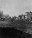
| Date: | 1868 |
|---|---|
| Description: | View of the west side of unpaved Water Street, looking south. |
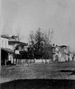
| Date: | 1868 |
|---|---|
| Description: | View of unpaved Water Street, showing a millinery shop. |
| Date: | 1868 |
|---|---|
| Description: | View of Water Street looking north from the business district. |

| Date: | 1868 |
|---|---|
| Description: | Stereograph view of the levee, with buildings along the left. Signs on the buildings read, left to right: "(?) Hotel", "Saloon" and "Dunbar's Hall." People... |

| Date: | 1868 |
|---|---|
| Description: | Showing the counties, towns and railroads. Partly colored. Scale: 1 inch = 20 miles. |

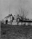
| Date: | 1868 |
|---|---|
| Description: | The Philteus Sawyer residence located on the northwest corner of Algoma and West Algoma Streets. Sawyer was mayor of Oshkosh from 1863-1864, and became a U... |
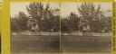
| Date: | 1868 |
|---|---|
| Description: | Stereograph of the Rublee house, among trees. The residence of Horace Rublee, formerly owned by J.A Ellis, on the east corner of Wisconsin Avenue and Gilma... |

| Date: | 1868 |
|---|---|
| Description: | A detailed, cloth mounted map of Grant County that shows the townships, towns, roads, completed and under construction railroads, cemeteries, mills, lead m... |

| Date: | 1868 |
|---|---|
| Description: | This map shows land ownership by name, lots, roads, railroads, and part of the Fox River. The map includes an explanation and table of witnesses to the cor... |
If you didn't find the material you searched for, our Library Reference Staff can help.
Call our reference desk at 608-264-6535 or email us at: