Filter: Categories of Wisconsin Historical Images
Filter: FULL_DATE of 1867
Filter: Subject of land use
Filter: Categories of Wisconsin Historical Images
Filter: FULL_DATE of 1867
Filter: Subject of land use

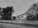
| Date: | 1867 |
|---|---|
| Description: | Drawn map showing planned development of Cornell, including a couple of schools, Oakwood cemetery, the public square, and several bridges and dams. |
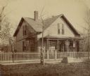
| Date: | 1867 |
|---|---|
| Description: | View across unpaved road towards Randall Wilcox's home, with a fence along the sidewalk. A group of people are standing on the front porch. |
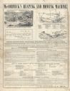
| Date: | 1867 |
|---|---|
| Description: | Directions for putting together and operating McCormick's Reaping and Mowing Machine. Features labeled drawings of the machine set up as a reaper and as a ... |

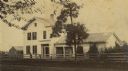
| Date: | 1867 |
|---|---|
| Description: | View across lawn toward a campus building at Ripon College. A stone commemorative marker is on the lawn on the right. Caption reads: "Scene, Ripon College,... |

| Date: | 1867 |
|---|---|
| Description: | This 1867 map shows the Chippewa River in northern Chippewa County, Wisconsin, from just north of Cornell to Jim Falls. Covering portions of the towns of A... |
If you didn't find the material you searched for, our Library Reference Staff can help.
Call our reference desk at 608-264-6535 or email us at: