 Filter: Categories of Wisconsin Historical Images
Filter: FULL_DATE of 1867
Filter: Subject of cities and towns
Filter: Categories of Wisconsin Historical Images
Filter: FULL_DATE of 1867
Filter: Subject of cities and towns

| Date: | 1867 |
|---|---|
| Description: | A map showing railroad land in Chippewa Valley. |
| Date: | 1867 |
|---|---|
| Description: | View across lawn toward the facade of West Hall at Ripon College. The entrance doors are elevated above ground level, reached by a large porch with curved ... |

| Date: | 1867 |
|---|---|
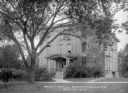
| Description: | View across lawn toward the facade of Bartlett Hall at Ripon College, partially obscured by trees. Brick is the primary building material used, although la... |

| Date: | 1867 |
|---|---|
| Description: | View across lawn toward the entrance and side of Bartlett Hall at Ripon College, partially obscured by trees. Decorative stone, wood, and brickwork all orn... |

| Date: | 1867 |
|---|---|
| Description: | View across lawn toward the commons building at Ripon College, partially obscured by trees. |
| Date: | 1867 |
|---|---|
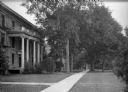
| Description: | View down sidewalk along a row of buildings at Ripon College. |

| Date: | 1867 |
|---|---|
| Description: | View across lawn toward a campus building at Ripon College. A stone commemorative marker is on the lawn on the right. Caption reads: "Scene, Ripon College,... |

| Date: | 1867 |
|---|---|
| Description: | This map of the battlefield on the North Anna River at Hanover Junction illustrates the Union positions in blue and Confederate positions in red. Roads, ra... |

| Date: | 1867 |
|---|---|
| Description: | Map of the entire state indicates county boundaries outlined in red, cities of over 3000 inhabitants and county seats. It also marks rivers and lakes. |

| Date: | 1867 |
|---|---|
| Description: | A hand-colored map of Wisconsin showing the state’s township grid, lakes, rivers, railroads, as well as the locations of towns, counties and the reservatio... |

| Date: | 1867 |
|---|---|
| Description: | This map, which includes eastern Iowa, northern Illinois and the western portion of Michigan's Upper peninsula, shows the township survey grid and identifi... |

| Date: | 1867 |
|---|---|
| Description: | This 1867 map shows the Chippewa River in northern Chippewa County, Wisconsin, from just north of Cornell to Jim Falls. Covering portions of the towns of A... |
| Date: | 1867 |
|---|---|
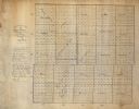
| Description: | This manuscript map shows the township and range grid, towns, and sections in Dodge County, Wisconsin. |
| Date: | 1867 |
|---|---|
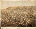
| Description: | Bird’s-eye view map. Indexed for points of interest. |

| Date: | 1867 |
|---|---|
| Description: | This map shows components of the bottom of Lake Michigan and the Root River, as well as the harbor, buildings, streets, railroads, and rural landowners in ... |

| Date: | 1867 |
|---|---|
| Description: | View across street towards the front of the 2nd Ward School building, which was located at 720 E. Gorham Street. |

| Date: | 1867 |
|---|---|
| Description: | This map shows actual and projected railroads in the region of La Crosse and Winona, running east to Sparta, Wisconsin and west to Lewiston and Rushford, M... |

| Date: | 1867 |
|---|---|
| Description: | A map and profile map of the railroad line from Omaha to San Francisco. |
If you didn't find the material you searched for, our Library Reference Staff can help.
Call our reference desk at 608-264-6535 or email us at: