 Filter: Categories of Wisconsin Historical Images
Filter: FULL_DATE of 1866
Filter: Subject of industries
Filter: Categories of Wisconsin Historical Images
Filter: FULL_DATE of 1866
Filter: Subject of industries
| Date: | 1866 |
|---|---|
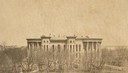
| Description: | The Third Wisconsin State Capitol before the completion of the dome. After all four wings of the Third Capitol were completed, the second Capitol was demo... |
| Date: | 1866 |
|---|---|
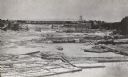
| Description: | Elevated view taken from the extreme end of Clark's Saw and Planing Mill. An old flour mill can be seen behind the bridge, and to the extreme right are thr... |
| Date: | 1866 |
|---|---|
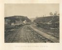
| Description: | View from railroad tracks through the Allatoona Pass. One of the buildings on the left says "Grocery," and piles of lumber are stacked along the sides of t... |

| Date: | 1866 |
|---|---|
| Description: | A map of Lafayette County, Wisconsin, showing the townships and ranges, sections, towns, villages, stream and rivers, mounds, mineral deposits and the Mine... |

| Date: | 1866 |
|---|---|
| Description: | This map shows the location of county boundaries, cities, rivers, lakes, grant railroads, wagon roads, land office locations, iron, copper and lead deposit... |

| Date: | 1866 |
|---|---|
| Description: | A colorful map of Gilpin County, the central gold region of Colorado, surveyed by Charles W. Morse and George Hill. |
If you didn't find the material you searched for, our Library Reference Staff can help.
Call our reference desk at 608-264-6535 or email us at: