 Filter: Categories of Wisconsin Historical Images
Filter: FULL_DATE of 1866
Filter: Subject of cities and towns
Filter: Categories of Wisconsin Historical Images
Filter: FULL_DATE of 1866
Filter: Subject of cities and towns
| Date: | 1866 |
|---|---|
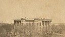
| Description: | The Third Wisconsin State Capitol before the completion of the dome. After all four wings of the Third Capitol were completed, the second Capitol was demo... |
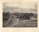
| Date: | 1866 |
|---|---|
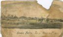
| Description: | An image from a sketchbook of the town of Iowa Falls. There is a fence in the foreground and buildings in the background. |
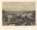
| Date: | 1866 |
|---|---|
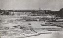
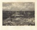
| Description: | Elevated view taken from the extreme end of Clark's Saw and Planing Mill. An old flour mill can be seen behind the bridge, and to the extreme right are thr... |
| Date: | 1866 |
|---|---|
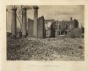
| Description: | The ruins of Columbia after Sherman passed through, with damaged buildings, free-standing columns, and a pile of rubble. Plate 55 |
| Date: | 1866 |
|---|---|
| Description: | Destruction of Columbia after General Sherman's men burned the town near the end of the Civil War. Plate 53 |
| Date: | 1866 |
|---|---|
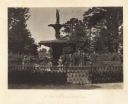
| Description: | A large fountain with statues. Two (Union?) soldiers are on the far side. Plate 78937 |
| Date: | 1866 |
|---|---|
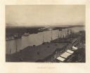
| Description: | Elevated view over storefronts and the river. Plate 50 |
| Date: | 1866 |
|---|---|
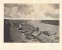
| Description: | Elevated view over storefronts and the river. Plate 49 |
| Date: | 1866 |
|---|---|
| Description: | Elevated view of commercial area of the city, taken after General Sherman marched through. Most of the buildings appear to be intact, but one of the build... |
| Date: | 1866 |
|---|---|
| Description: | Elevated view of the ruins of the railroad roundhouse, with the city in the background. Men are posing on the train cars and engines. Plate 45 |
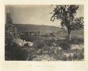
| Date: | 1866 |
|---|---|
| Description: | View of Ringgold in the far distance. A tree and pile of rubble, perhaps the remains of a fireplace, in the foreground. Plate 17 |
| Date: | 1866 |
|---|---|
| Description: | Elevated view of the Chattanooga Valley, with a river in the far background. A cliff face and trees are in the foreground. Plate 14 |
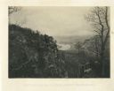
| Date: | 1866 |
|---|---|
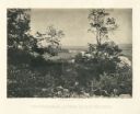
| Description: | View of the Chattanooga Valley and a river from Lookout Mountain. Trees are in the foreground, and a city is in the background across the river. Plate 1... |
| Date: | 1866 |
|---|---|
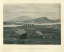
| Description: | Two log buildings are in the foreground. A bridge spans a river in the middle distance, and the city of Chattanooga is on the far side at the base of a mou... |

| Date: | 1866 |
|---|---|
| Description: | This thematic shows the effects that Lake Michigan has had on Wisconsin mean temperatures in January and July. The map shows counties, some cities, rivers ... |

| Date: | 1866 |
|---|---|
| Description: | A pen on paper, hand-drawn and colored map of Wisconsin and Michigan, showing counties, cities and villages, rivers and lakes, as well as railroads are in ... |

| Date: | 1866 |
|---|---|
| Description: | A pen on paper, hand-drawn and colored map of Wisconsin and Michigan, showing counties, cities and villages, rivers and lakes, as well as railroads are in ... |

| Date: | 1866 |
|---|---|
| Description: | This map shows the railroads both completed and under construction in southern Wisconsin, Iowa, Illinois, and Missouri. Railroad terminals, junctions, and ... |

| Date: | 1866 |
|---|---|
| Description: | A map of Lafayette County, Wisconsin, showing the townships and ranges, sections, towns, villages, stream and rivers, mounds, mineral deposits and the Mine... |

| Date: | 1866 |
|---|---|
| Description: | This map shows the location of county boundaries, cities, rivers, lakes, grant railroads, wagon roads, land office locations, iron, copper and lead deposit... |
If you didn't find the material you searched for, our Library Reference Staff can help.
Call our reference desk at 608-264-6535 or email us at: