Filter: Categories of Wisconsin Historical Images
Filter: FULL_DATE of 1865
Filter: Subject of cities and towns
Filter: Subject of dwellings
Filter: Categories of Wisconsin Historical Images
Filter: FULL_DATE of 1865
Filter: Subject of cities and towns
Filter: Subject of dwellings
| Date: | 1865 |
|---|---|
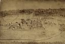
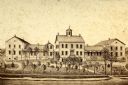
| Description: | University of Wisconsin-Madison campus showing the first three buildings on campus, South Hall (left), University Hall [Bascom Hall] (center), and North Ha... |
| Date: | 1865 |
|---|---|
| Description: | South Wisconsin Avenue and West Main Street. Lake Monona is in the background and the Lucius Fairchild and David Atwood houses are at the upper left. The r... |

| Date: | 1865 |
|---|---|
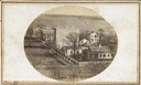
| Description: | Elevated view of the Congregational church and surrounding buildings. |

| Date: | 1865 |
|---|---|
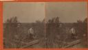
| Description: | Family portrait of the Porters, standing in front of their log cabin with a horse. |
| Date: | 1865 |
|---|---|
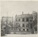
| Description: | Stereograph elevated view of a home in Lancaster. |

| Date: | 1865 |
|---|---|
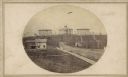
| Description: | Harvey Hospital, or the Soldiers' Orphans Home. The main octagon section was the home of Governor Farwell, and the wing of wood was added in 1862 and used ... |
| Date: | 1865 |
|---|---|
| Description: | View of a mission house, erected between 1862 and 1873. |
| Date: | 1865 |
|---|---|
| Description: | After the fire of Oct. 22, 1865. The house takes up most of the image to the right, with burnt trees on the left, and a building in the background. The r... |
| Date: | 1865 |
|---|---|
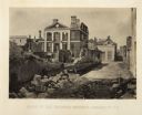
| Description: | Ruins of the Pinckney Mansion with rubble in the street after General Sherman's men burned the town near the end of the Civil War. Plate 59 |

| Date: | 1865 |
|---|---|
| Description: | This detailed map of the area between Richmond and Petersburg shows fortifications, roads, railroads, towns, street patterns of Petersburg and Richmond, dr... |

| Date: | 1865 |
|---|---|
| Description: | The map of the battlefield shows entrenchments, villages, roads, the "South Side Rail Road" drainage, vegetation, relief by hachures, houses, and names of ... |
If you didn't find the material you searched for, our Library Reference Staff can help.
Call our reference desk at 608-264-6535 or email us at: