 Filter: Categories of Wisconsin Historical Images
Filter: FULL_DATE of 1864
Filter: Subject of rivers
Filter: Categories of Wisconsin Historical Images
Filter: FULL_DATE of 1864
Filter: Subject of rivers
| Date: | 1864 |
|---|---|
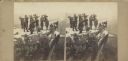
| Description: | Albumen stereograph of the Union Army brass band posed and playing atop Lookout Point. The Tennessee River is in the background. |

| Date: | 1864 |
|---|---|
| Description: | This map shows pictorially a section of bracketdam, section of tree dam, and crib of stone. This map was prepared by order of General Joseph Bailey and is ... |
| Date: | 1864 |
|---|---|
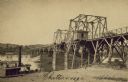
| Description: | Carte-de-visite of a bridge at Chattanooga with a steamship passing nearby. |

| Date: | 1864 |
|---|---|
| Description: | Map reads: "Johnson's Wisconsin and Michigan". There is a decorative border, a scale of which ten miles is approximately one inch and individual counties d... |

| Date: | 1864 |
|---|---|
| Description: | View across the Tennessee River toward the city and Cameron Hill, showing the military bridge and some Union Army installations put up following the occupa... |
| Date: | 1864 |
|---|---|
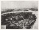
| Description: | Aerial view, probably from a lithograph, of the prison for Confederate soldiers at Rock Island. |

| Date: | 1864 |
|---|---|
| Description: | View down to valley of Union soldiers posing on the roof of a log building. A log bridge crosses a stream, and many trees are on the hillsides. Plate 05... |
| Date: | 1864 |
|---|---|
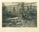
| Description: | View from shoreline of tall trestle bridge on the railroad line crossing the river at Whiteside. Two men sit on logs in the river on the left. More men sit... |

| Date: | 1864 |
|---|---|
| Description: | (U.S. 39th Cong. 1stt Sess. Report of Chief engineer) The legend in the upper left corner contains a brief resume of each day's action while the map sho... |

| Date: | 1864 |
|---|---|
| Description: | This map of the battlefield on the North Anna River at Hanover Junction illustrates the Union positions in blue and Confederate positions in red. Roads, ra... |

| Date: | 1864 |
|---|---|
| Description: | This colored map of the southern and eastern states shows locations of battles and skirmishes from 1861 through May 1864 with red dots or red underlining o... |

| Date: | 1864 |
|---|---|
| Description: | A geological map of Wisconsin that shows the locations of different rock deposits such as limestone, sandstone, shale, plutonic and the Penokee Iron Range.... |

| Date: | 1864 |
|---|---|
| Description: | This map of the entire state of Wisconsin depicts the township survey grid and identifies counties, named towns, cities and villages, rivers, lakes, railro... |

| Date: | 1864 |
|---|---|
| Description: | This map is pen and watercolor on paper and shows a profile and geological sections of the Blue Mounds, Hollow Run, Bogies Hollow Run, Bear Creek, East Bre... |

| Date: | 1864 |
|---|---|
| Description: | This map is pen and watercolor on paper and shows a profile and geological sections of the East Blue Mound Break, Blue Mound Creek, Black Earth River, and ... |

| Date: | 1864 |
|---|---|
| Description: | This map is pen and watercolor on paper and shows a profile and geological sections of the Apple River, Little Otter Creek, Woods' Branch, Bonners' Branch,... |

| Date: | 1864 |
|---|---|
| Description: | This map is pen and watercolor on paper and shows a profile and geological sections of the Spensley Break, James Break, Wisconsin River, and Little Bear Cr... |

| Date: | 1864 |
|---|---|
| Description: | This map shows locations of quarries, sink holes, creeks, springs, rivers, houses, forts, and roads. Annotations in pencil read: "Is the top of the mound l... |

| Date: | 1864 |
|---|---|
| Description: | This map shows locations of quarries, sink holes, creeks, springs, rivers, houses, forts, and roads. The upper right corner and right margin includes anno... |
If you didn't find the material you searched for, our Library Reference Staff can help.
Call our reference desk at 608-264-6535 or email us at:
