 Filter: Categories of Wisconsin Historical Images
Filter: FULL_DATE of 1864
Filter: Subject of land
Filter: Categories of Wisconsin Historical Images
Filter: FULL_DATE of 1864
Filter: Subject of land
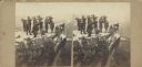
| Date: | 1864 |
|---|---|
| Description: | Albumen stereograph of the Union Army brass band posed and playing atop Lookout Point. The Tennessee River is in the background. |

| Date: | 1864 |
|---|---|
| Description: | This map shows pictorially a section of bracketdam, section of tree dam, and crib of stone. This map was prepared by order of General Joseph Bailey and is ... |
| Date: | 1864 |
|---|---|
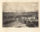
| Description: | Elevated view of Battery C, 1st Regiment, Wisconsin Heavy Artillery at Fort Sherman, shown here after the battles of Missionary Ridge and Lookout Mountain.... |
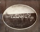
| Date: | 1864 |
|---|---|
| Description: | Oval-framed view of the village, founded by Delos W. Taft, had its name changed to Bloomington in 1867. It had been named Tafton. |
| Date: | 1864 |
|---|---|
| Description: | A painting of the Grignon house and surrounding land and water. |

| Date: | 1864 |
|---|---|
| Description: | Fort Crawford was decommissioned in 1856, having outlived its usefulness as a frontier post. During the Civil War, however, it functioned as a military ho... |

| Date: | 1864 |
|---|---|
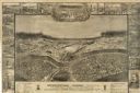
| Description: | Map reads: "Johnson's Wisconsin and Michigan". There is a decorative border, a scale of which ten miles is approximately one inch and individual counties d... |

| Date: | 1864 |
|---|---|
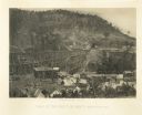
| Description: | View across the Tennessee River toward the city and Cameron Hill, showing the military bridge and some Union Army installations put up following the occupa... |
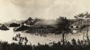
| Date: | 1864 |
|---|---|
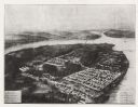
| Description: | Aerial view, probably from a lithograph, of the prison for Confederate soldiers at Rock Island. |
| Date: | 1864 |
|---|---|
| Description: | "Andersonville Prison, Camp Sumter, Ga., as it appeared August 1st 1864 when it contained 35,000 prisoners of war." |
| Date: | 1864 |
|---|---|
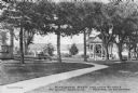
| Description: | View across lawn toward a gazebo, section of a porch, and benches on the campus of St. Mary Academy. The lawn overlooks the Iowa Bluffs across the Mississi... |
| Date: | 1864 |
|---|---|
| Description: | Confederate defenses surrounding the city. A tripod style configuration of rifles with a bag and canteen hanging from it is in the foreground. Plate 43<... |
| Date: | 1864 |
|---|---|
| Description: | One of the Confederate defenses surrounding the city. This view is of the inside of the earthworks which includes two cannons. A Union soldier sits as a lo... |

| Date: | 1864 |
|---|---|
| Description: | View looking out from one of the Confederate defenses around the outside of the city. Wooden palisades surround the earthworks. Houses and other buildings ... |
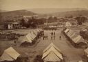
| Date: | 1864 |
|---|---|
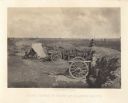
| Description: | View down hillside of Union soldiers standing in front of a group of tents. There is a valley and mountains in the distance. Plate 07 |
| Date: | 1864 |
|---|---|
| Description: | Union soldiers stand by their tents in front of a trestle bridge on the railroad line that spans a valley. A mountain is in the background. Plate 06 |

| Date: | 1864 |
|---|---|
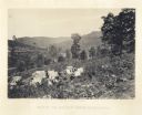
| Description: | View down to valley of Union soldiers posing on the roof of a log building. A log bridge crosses a stream, and many trees are on the hillsides. Plate 05... |

| Date: | 1864 |
|---|---|
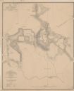
| Description: | (U.S. 39th Cong. 1stt Sess. Report of Chief engineer) The legend in the upper left corner contains a brief resume of each day's action while the map sho... |
| Date: | 1864 |
|---|---|
| Description: | This map depicts the battlefield at Todd's Tavern, Va., the site of a battle on May 7-8, 1864. Depicted are roads, houses, drainage, vegetation and troop p... |

| Date: | 1864 |
|---|---|
| Description: | This map of the Battle of Gettysburg indicates Union positions in red and Confederate positions in blue. Also shown are artillery positions, roads, railroa... |
If you didn't find the material you searched for, our Library Reference Staff can help.
Call our reference desk at 608-264-6535 or email us at: