 Filter: Categories of Wisconsin Historical Images
Filter: FULL_DATE of 1863
Filter: Subject of military art and science
Filter: Categories of Wisconsin Historical Images
Filter: FULL_DATE of 1863
Filter: Subject of military art and science
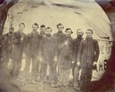
| Date: | 1863 |
|---|---|
| Description: | The men in this tintype image were among 500 soldiers taken prisoner at Brentwood on March 25, 1863 and sent to Richmond. They were exchanged for Confedera... |
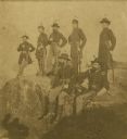
| Date: | 1863 |
|---|---|
| Description: | The Twenty-First Wisconsin Volunteer Infantry posing on Lookout Mountain. From right to left: Fred W. Borcherdt of Manitowoc, Wisconsin; acting Adjutant Co... |
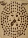
| Date: | 1863 |
|---|---|
| Description: | Composite of photographic portraits of soldiers, and at the top left and right corners, two camp scenes, of the Seventh Wisconsin Light Artillery Battery. ... |

| Date: | 1863 |
|---|---|
| Description: | This map shows roads, railroads, settlements, farms with owners' names, vegetation, streams, and fords in Culpeper County region during the Civil War. A ma... |

| Date: | 1863 |
|---|---|
| Description: | This map is a hand-colored, pen and ink, drawing by Ole R. Dahl of Co. B, 15 Wisconsin Infantry shows the battlefield at Stones River, depicting roads, str... |

| Date: | 1863 |
|---|---|
| Description: | These detailed topographical maps of the Battle of Gettysburg show drainage, vegetation, roads, railroads, fences, houses with names of residents, and a de... |

| Date: | 1863 |
|---|---|
| Description: | These detailed topographical maps of the Battle of Gettysburg show drainage, vegetation, roads, railroads, fences, houses with names of residents, and a de... |

| Date: | 1863 |
|---|---|
| Description: | A general map of the southeastern United States showing Missouri, Kentucky, West Virginia, Virginia, North Carolina, South Carolina, Georgia, Florida, Alab... |
If you didn't find the material you searched for, our Library Reference Staff can help.
Call our reference desk at 608-264-6535 or email us at: