 Filter: Categories of Wisconsin Historical Images
Filter: FULL_DATE of 1862
Filter: Subject of human settlements
Filter: Subject of transportation
Filter: Categories of Wisconsin Historical Images
Filter: FULL_DATE of 1862
Filter: Subject of human settlements
Filter: Subject of transportation

| Date: | 1862 |
|---|---|
| Description: | Drawn the second year of the Civil War, this 1862 map of Milwaukee shows post offices, light houses, beacon lights, county buildings, elevator warehouses, ... |

| Date: | 1862 |
|---|---|
| Description: | John S. Fuller took this image of the third Wisconsin State Capitol (the second in Madison), from Governor Farwell's Octagon House, probably early in 1862.... |
| Date: | 1862 |
|---|---|
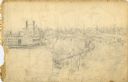
| Description: | This is the preliminary sketch for "Hamburg Landing, 4 miles below Pittsburg Landing, Commisary [sic] Depot of Gen. Hallek's Army." Shows an encampm... |

| Date: | 1862 |
|---|---|
| Description: | Lithography of C. Van Benthuysen. |

| Date: | 1862 |
|---|---|
| Description: | Birds-eye view of a Wisconsin Civil War regiment on parade in Fond du Lac, as drawn by Louis Kurz from the Marr Street Methodist Church. The regiment canno... |

| Date: | 1862 |
|---|---|
| Description: | This map shows the region of southeastern Virginia which served as the setting for the Peninsular Campaign of 1862. A few battle sites are marked by crosse... |

| Date: | 1862 |
|---|---|
| Description: | This map of the Battle of Shiloh shows relief by hachures, vegetation, drainage, houses, fields, fences, mills, and roads and is color coded to show the mo... |

| Date: | 1862 |
|---|---|
| Description: | This map of the southeastern United States shows cities and towns, rail lines, and geographic features such as rivers, mountains, lakes, and swamps. |

| Date: | 1862 |
|---|---|
| Description: | This map of the southeastern United States shows forts and battlefields, railroads, rivers, and cities and towns. Dates of admission and secession of the s... |

| Date: | 1862 |
|---|---|
| Description: | This map of eastern Virginia and Maryland shows rivers, roads and railroads from Hagerstown, Maryland, south to Suffolk, Virginia, and west to Staunton, Vi... |

| Date: | 1862 |
|---|---|
| Description: | Map of southeastern Virginia indicating fortifications, towns, roads, railroads, drainage, and some vegetation. 2 sheets, each mounted on 1 sheet. |

| Date: | 1862 |
|---|---|
| Description: | This detailed map shows batteries and rifle pits, railroads, common and military roads, turnpikes, city streets and names, bridges, ferries, rural houses a... |
| Date: | 1862 |
|---|---|
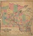
| Description: | This hand-colored map shows railroads in Minnesota, Wisconsin, eastern Iowa, and northern Illinois. The township survey grid, counties, cities and villages... |
| Date: | 1862 |
|---|---|
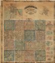
| Description: | This map shows townships, landownership, roads, railroads, and swampland in Jefferson County. There is an inset maps showing the towns of: Watertown, Jeffe... |

| Date: | 1862 |
|---|---|
| Description: | This 1862 map of Sheboygan County, Wisconsin, shows land ownership and acreages, the township and range grid, towns, cities and villages, roads, railroads,... |

| Date: | 1862 |
|---|---|
| Description: | This map shows townships and sections, landownership and acreages, roads, railroads, cemeteries, churches, schools, mills, and stone quarries. "Engraved, p... |

| Date: | 1862 |
|---|---|
| Description: | This 1862 map of Winnebago County, Wisconsin, shows the township and range grid, towns, sections, cities and villages, railroads, roads, property owners an... |

| Date: | 1862 |
|---|---|
| Description: | Shows townships and sections, landownership and acreage, roads, railroads, churches, schools, and cemeteries. Inset maps: Plat of Hingham -- Plat of Casca... |
If you didn't find the material you searched for, our Library Reference Staff can help.
Call our reference desk at 608-264-6535 or email us at: