Filter: Categories of Wisconsin Historical Images
Filter: FULL_DATE of 1861
Filter: Subject of transportation
Filter: Categories of Wisconsin Historical Images
Filter: FULL_DATE of 1861
Filter: Subject of transportation

| Date: | 1861 |
|---|---|
| Description: | View of Madison from Main Hall, now Bascom Hall, on the University of Wisconsin-Madison campus looking up State Street toward the second Wisconsin State Ca... |

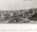
| Date: | 1861 |
|---|---|
| Description: | Bird's-eye map of Fond du Lac, "drawn after nature," with a parade of soldiers marching down the street. |
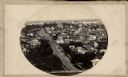
| Date: | 1861 |
|---|---|
| Description: | View up State Street looking toward the Wisconsin State Capitol from the roof of University Hall (later Bascom Hall), about 1860 or 1861. Actually the pho... |

| Date: | 1861 |
|---|---|
| Description: | A map of Wisconsin showing cities, counties, major roads, railroads, and bodies of water. Includes an inset of the vicinity of Milwaukee. |
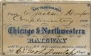
| Date: | 1861 |
|---|---|
| Description: | Chicago and Northwestern Railway pass belonging to Reverend Jackson Kemper. |

| Date: | 1861 |
|---|---|
| Description: | 1861 Racine and Mississippi Railroad Pass belonging to Jackson Kemper. |
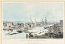
| Date: | 1861 |
|---|---|
| Description: | Lithograph illustration of downtown Chicago near the Rush Street bridge (a "swing bridge"). The McCormick Reaper Works and other factory buildings are on t... |

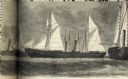
| Date: | 1861 |
|---|---|
| Description: | Panoramic view of downtown Chicago before the fire of 1871. The photograph was taken from the South side of the Chicago River, looking Northeast. The Rush ... |

| Date: | 1861 |
|---|---|
| Description: | A general map of Pennsylvania, Virginia, New Jersey and Delaware. Insets include maps of New Orleans, Baltimore, St. Louis, Charleston, Savannah, Washingto... |

| Date: | 1861 |
|---|---|
| Description: | Shows townships and sections, landowners, and woodlands. Includes inset maps of Monroe, Brodhead, Albany, Cadiz, Decatur, Dayton, Clarence, Springfield, Tw... |

| Date: | 1861 |
|---|---|
| Description: | This map of the entire state of Wisconsin depicts the township survey grid and identifies counties, named towns, cities and villages, rivers, lakes, railro... |

| Date: | 1861 |
|---|---|
| Description: | This 1861 map of Columbia County, Wisconsin, shows the township and range grid, towns, sections, cities and villages, railroads, roads, property owners and... |

| Date: | 1861 |
|---|---|
| Description: | Map with labelled block and lot numbers, owners of large property parcels, city wards, railroads, and streets. Population from 1835 to 1860 listed below ti... |

| Date: | 1861 |
|---|---|
| Description: | Depths shown by soundings. Shows township and sections, landownership and acreages, roads, railroads, and buildings. "Entered according to Act of Congress ... |

| Date: | 1861 |
|---|---|
| Description: | The township of Primrose, which is a detail from the plat map of Dane County. |

| Date: | 1861 |
|---|---|
| Description: | The township of Montrose, which is a detail from a Dane County plat map. |

| Date: | 1861 |
|---|---|
| Description: | This map shows lot and block numbers, piers, streets, monuments, and township section corners. Included is a note on the width of avenues, piers, slips, al... |

| Date: | 1861 |
|---|---|
| Description: | This map shows townships and sections, landownership, roads, railroads, rural residences, schools, churches, and topography. Also included are inset maps o... |
If you didn't find the material you searched for, our Library Reference Staff can help.
Call our reference desk at 608-264-6535 or email us at: