 Filter: Categories of Wisconsin Historical Images
Filter: FULL_DATE of 1861
Filter: County of Dane
Filter: Subject of human settlements
Filter: Subject of water
Filter: Categories of Wisconsin Historical Images
Filter: FULL_DATE of 1861
Filter: County of Dane
Filter: Subject of human settlements
Filter: Subject of water

| Date: | 1861 |
|---|---|
| Description: | Drawn the first year of the Civil War, this colored 1861 map of Dane County shows its towns, cities and lakes. It includes insets of the wards of Madison a... |
| Date: | 1861 |
|---|---|
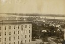
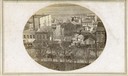
| Description: | View of Madison from Main Hall, now Bascom Hall, on the University of Wisconsin-Madison campus. South Hall is in the foreground, with several residences an... |
| Date: | 1861 |
|---|---|
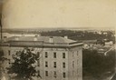
| Description: | View of Madison from Main Hall, now Bascom Hall, on the University of Wisconsin-Madison campus. South Hall is in the foreground with several residences an... |

| Date: | 1861 |
|---|---|
| Description: | View of Madison from Main Hall, now Bascom Hall, on the University of Wisconsin-Madison campus looking up State Street toward the second Wisconsin State Ca... |
| Date: | 1861 |
|---|---|
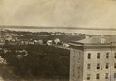
| Description: | View of Madison from Main Hall, now Bascom Hall, on the University of Wisconsin-Madison campus. North Hall is in the foreground with several residences and... |
| Date: | 1861 |
|---|---|
| Description: | East (King Street) wing of the third Wisconsin State Capitol and the south wall of the Territorial Capitol (at the left) taken from the roof of the buildin... |
| Date: | 1861 |
|---|---|
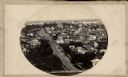
| Description: | First block of East Main street photographed from the roof of the Wisconsin State Capitol building. Doty and Wilson street properties and Lake Monona are i... |
| Date: | 1861 |
|---|---|
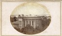
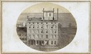
| Description: | The Vilas Hotel located at the corner of Monona Avenue at the west end of the first block of East Main Street. |
| Date: | 1861 |
|---|---|
| Description: | View up State Street looking toward the Wisconsin State Capitol from the roof of University Hall (later Bascom Hall), about 1860 or 1861. Actually the pho... |

| Date: | 1861 |
|---|---|
| Description: | The township of Primrose, which is a detail from the plat map of Dane County. |

| Date: | 1861 |
|---|---|
| Description: | The township of Montrose, which is a detail from a Dane County plat map. |
If you didn't find the material you searched for, our Library Reference Staff can help.
Call our reference desk at 608-264-6535 or email us at: