Filter: Categories of Wisconsin Historical Images
Filter: FULL_DATE of 1861
Filter: County of Dane
Filter: Creator Name of Unknown
Filter: Categories of Wisconsin Historical Images
Filter: FULL_DATE of 1861
Filter: County of Dane
Filter: Creator Name of Unknown

| Date: | 1861 |
|---|---|
| Description: | Drawn the first year of the Civil War, this colored 1861 map of Dane County shows its towns, cities and lakes. It includes insets of the wards of Madison a... |

| Date: | 1861 |
|---|---|
| Description: | Dane County plat map of the town of Windsor. |
| Date: | 1861 |
|---|---|
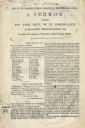
| Description: | Printed copy of a sermon, "The Duty of the Northern States in Relation to the Future of Slavery," delivered by Rev. William Henry Brisbane, minister of the... |
| Date: | 1861 |
|---|---|
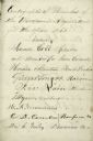
| Description: | A page of autographs of the members of the 1861 Wisconsin Legislature. |
| Date: | 1861 |
|---|---|
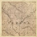
| Description: | A map of the Verona Township, which is a section of a larger Dane County map. |

| Date: | 1861 |
|---|---|
| Description: | The township of Primrose, which is a detail from the plat map of Dane County. |

| Date: | 1861 |
|---|---|
| Description: | The township of Montrose, which is a detail from a Dane County plat map. |
If you didn't find the material you searched for, our Library Reference Staff can help.
Call our reference desk at 608-264-6535 or email us at: