Filter: Categories of Wisconsin Historical Images
Filter: FULL_DATE of 1860
Filter: Categories of Wisconsin Historical Images
Filter: FULL_DATE of 1860
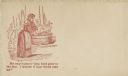
| Date: | 1860 |
|---|---|
| Description: | A woman is washing clothes in a washtub. The caption below reads "My only support—both boys gone to the war. I wonder if they would take me?" Red ink on be... |
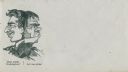
| Date: | 1860 |
|---|---|
| Description: | A figure has two faces. Facing left a smiling (Union) face is saying "How about Washington?" Facing right a grumpy (Confederate) face is saying "Let me alo... |

| Date: | 1860 |
|---|---|
| Description: | Jefferson Davis, seated on the floor, is blowing bubbles and General Winfield Scott, standing, is bursting them with his sword. The soap dish on a table in... |

| Date: | 1860 |
|---|---|
| Description: | Stereograph of the Townsend House boathouse across a lake. |
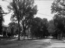
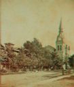
| Date: | 1860 |
|---|---|
| Description: | A view of a tree-lined residential street with houses partially visible on the left. |
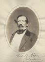
| Date: | 1860 |
|---|---|
| Description: | Waist-up oval portrait of Frederick W. Horn (1815-1893). A Democrat, he was a Representative in the Wisconsin Assembly from Cedarburg. He was a lawyer and ... |
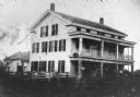
| Date: | 1860 |
|---|---|
| Description: | The oldest known image of the Wade House (taken from Ambrotype) with the Sheboygan/Fond du Lac Plank Road in the foreground. |

| Date: | 1860 |
|---|---|
| Description: | This colored map shows railroad lines east of the Mississippi as well as in the states bordering the Mississippi River. The Great Lakes and Gulf of Mexico ... |

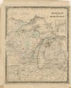
| Date: | 1860 |
|---|---|
| Description: | A map of Wisconsin showing the railroads, rivers, counties, cities, villages, and named towns in the state, as well as the township grid for the portion of... |
| Date: | 1860 |
|---|---|
| Description: | A hand-colored map showing the counties, major cities, ports, railroads, rivers and lakes in Wisconsin, Michigan, northern Illinois, and eastern Minnesota.... |

| Date: | 1860 |
|---|---|
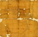
| Description: | A hand-drawn, ink on cloth map of southeastern Wisconsin that show roads and railroads that connect Chicago to Milwaukee and other towns in the southeaster... |

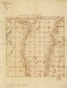
| Date: | 1860 |
|---|---|
| Description: | A survey map of Wisconsin, southeastern Minnesota, and northern Iowa, showing the status of surveys, rivers, and lakes. The map also shows the locations of... |

| Date: | 1860 |
|---|---|
| Description: | Sixth plate ambrotype portrait of a woman and a young girl. The woman is seated, and the girl is standing beside her resting her hand on the woman's should... |

| Date: | 1860 |
|---|---|
| Description: | This map, traced from John Farmer's 1860 Map of the states of Michigan and Wisconsin, shows the boundary between Michigan's Upper Peninsula and northern Wi... |
| Date: | 1860 |
|---|---|
| Description: | This manuscript map shows the surveyed areas of the Town of Aztalan, Jefferson County, Wisconsin. Acreage of the surveyed parcels is given and lakes and st... |

| Date: | 1860 |
|---|---|
| Description: | This map of Dodge County, Wisconsin, shows the township and range grid, towns, sections, cities and villages, railroads, roads, property owners and acreage... |
| Date: | 1860 |
|---|---|
| Description: | Pencil and ink on paper. "Showing the government meander line on the left bank of Rock River and the actual course of Rock River together with the several ... |

| Date: | 1860 |
|---|---|
| Description: | Waist-up studio portrait of Charles Fairchild in uniform. He was a paymaster in the U.S. Navy. |

| Date: | 1860 |
|---|---|
| Description: | Map shows meadows, forests, buildings, railroad, and lots south of part of the city of Milwaukee. Relief shown by hachures. Includes list of lot acreages. |
If you didn't find the material you searched for, our Library Reference Staff can help.
Call our reference desk at 608-264-6535 or email us at: