 Filter: Categories of Wisconsin Historical Images
Filter: FULL_DATE of 1860
Filter: Subject of streets
Filter: Categories of Wisconsin Historical Images
Filter: FULL_DATE of 1860
Filter: Subject of streets
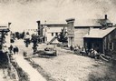
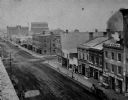
| Date: | 1860 |
|---|---|
| Description: | Elevated view of Barstow Street looking north. View from the corner of Main Street, where the Eau Claire Book and Stationary Company later stood, looking n... |

| Date: | 1860 |
|---|---|
| Description: | Bird's-eye drawing of New Glarus. |
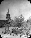
| Date: | 1860 |
|---|---|
| Description: | Elevated wintertime view of the intersection of South Carroll and West Main Streets, showing the First Baptist Church constructed in 1854, the wooden fence... |
| Date: | 1860 |
|---|---|
| Description: | View across Capitol Park lawn towards the corner of West Main and South Carroll Streets with businesses and horse-drawn wagons. The building at the corner ... |
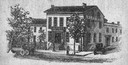
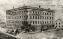
| Date: | 1860 |
|---|---|
| Description: | Engraving of the American House at 1 North Pinckney Street. It burned down in a fire in 1868. |
| Date: | 1860 |
|---|---|
| Description: | Elevated view of the Durkee House built by Charles Durkee in 1843. |
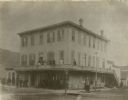
| Date: | 1860 |
|---|---|
| Description: | View across intersection towards the Alba House, with individuals standing outside its entrance and on the balcony. |
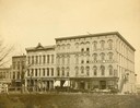
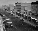
| Date: | 1860 |
|---|---|
| Description: | Elevated view of east side of Main Street, with Raymond & Jones Hardware visible at 112 Main Street. |
| Date: | 1860 |
|---|---|
| Description: | Elevated view of east side of Main Street, with Langlois & Robilliard visible at 137 Main Street. |
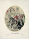
| Date: | 1860 |
|---|---|
| Description: | This color lithograph shows Giuseppe Garibaldi and his red shirts entering Naples, Italy, on horseback as women shower them with flowers. This is a romanti... |
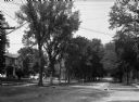
| Date: | 1860 |
|---|---|
| Description: | A view of a tree-lined residential street with houses partially visible on the left. |

| Date: | 1860 |
|---|---|
| Description: | This map of Dodge County, Wisconsin, shows the township and range grid, towns, sections, cities and villages, railroads, roads, property owners and acreage... |

| Date: | 1860 |
|---|---|
| Description: | This map of Superior is oriented with north to the upper left. Relief is shown by hachures and water depths are shown by soundings. Lake Superior and bays ... |

| Date: | 1860 |
|---|---|
| Description: | Map showing a plat of the city, land ownership by name, wards by number, local streets, buildings, fair grounds, nurseries, and part of Rock River. The map... |
If you didn't find the material you searched for, our Library Reference Staff can help.
Call our reference desk at 608-264-6535 or email us at: