 Filter: Categories of Wisconsin Historical Images
Filter: FULL_DATE of 1860
Filter: Subject of roads
Filter: Categories of Wisconsin Historical Images
Filter: FULL_DATE of 1860
Filter: Subject of roads
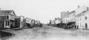
| Date: | 1860 |
|---|---|
| Description: | College Avenue looking west from the corner of Morrison Street. The building on the left is the Adkins Building, at the right is the Johnston House. This w... |

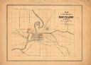
| Date: | 1860 |
|---|---|
| Description: | Bird's-eye drawing of New Glarus. |
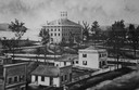
| Date: | 1860 |
|---|---|
| Description: | Elevated illustration of the Lawrence College Campus with snow on the ground. |
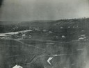
| Date: | 1860 |
|---|---|
| Description: | Elevated view of multiple buildings in Cross Plains from Lutheran Church Hill. Many roads and fences cross the fields. Wooded hills are in the background. ... |
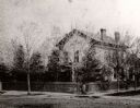
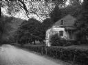
| Date: | 1860 |
|---|---|
| Description: | The home of I.G. Merrill on the corner of Ann Street (now called Sheridan Road) and Prairie Avenue. A person is standing in front of the fence at the corne... |
| Date: | 1860 |
|---|---|
| Description: | View of an old cabin, built in 1860, on the grounds of the Bedford Springs Hotel. In the foreground is a dirt road, and a pedestrian is walking near the fe... |

| Date: | 1860 |
|---|---|
| Description: | A hand-drawn, ink on cloth map of southeastern Wisconsin that show roads and railroads that connect Chicago to Milwaukee and other towns in the southeaster... |

| Date: | 1860 |
|---|---|
| Description: | This map of Dodge County, Wisconsin, shows the township and range grid, towns, sections, cities and villages, railroads, roads, property owners and acreage... |

| Date: | 1860 |
|---|---|
| Description: | Map showing a plat of the city, land ownership by name, wards by number, local streets, buildings, fair grounds, nurseries, and part of Rock River. The map... |
| Date: | 1860 |
|---|---|
| Description: | This map has relief shown by hachures and shows roads, railroads, proposed railroads, creeks, Half Moon Lake, Mount Adin, Mount Tom, Mount Sumeon, and part... |

| Date: | 1860 |
|---|---|
| Description: | This map shows roads, railroads, rivers, townships, school houses, churches, cemeteries, and land ownership by name. Relief is shown by hachures. The map i... |

| Date: | 1860 |
|---|---|
| Description: | This map shows roads, trails, and railroads throughout Nebraska, Arkansas, Missouri, Kansas, Illinois, and Utah, including the Salt Lake City & California ... |
If you didn't find the material you searched for, our Library Reference Staff can help.
Call our reference desk at 608-264-6535 or email us at: