 Filter: Categories of Wisconsin Historical Images
Filter: FULL_DATE of 1860
Filter: Subject of neighborhoods
Filter: Categories of Wisconsin Historical Images
Filter: FULL_DATE of 1860
Filter: Subject of neighborhoods
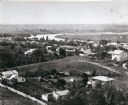
| Date: | 1860 |
|---|---|
| Description: | Elevated view of the Janesville Countryside. |
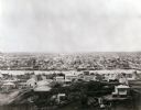
| Date: | 1860 |
|---|---|
| Description: | Elevated view of Janesville with a residential area in the foreground and the business district in the background. |

| Date: | 1860 |
|---|---|
| Description: | View of St. John's Catherdral with the original tower. |
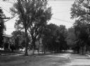
| Date: | 1860 |
|---|---|
| Description: | A view of a tree-lined residential street with houses partially visible on the left. |

| Date: | 1860 |
|---|---|
| Description: | Map shows meadows, forests, buildings, railroad, and lots south of part of the city of Milwaukee. Relief shown by hachures. Includes list of lot acreages. |
If you didn't find the material you searched for, our Library Reference Staff can help.
Call our reference desk at 608-264-6535 or email us at: