 Filter: Categories of Wisconsin Historical Images
Filter: FULL_DATE of 1860
Filter: Subject of land
Filter: Categories of Wisconsin Historical Images
Filter: FULL_DATE of 1860
Filter: Subject of land

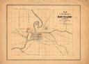
| Date: | 1860 |
|---|---|
| Description: | Bird's-eye drawing of New Glarus. |
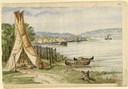
| Date: | 1860 |
|---|---|
| Description: | In April of 1860 Hölzlhuber took the railway from Milwaukee to Lake Horicon to visit the small town that was developing on its shore. Since the settlers we... |
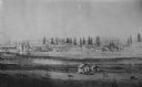
| Date: | 1860 |
|---|---|
| Description: | Elevated view of multiple buildings in Cross Plains from Lutheran Church Hill. Many roads and fences cross the fields. Wooded hills are in the background. ... |
| Date: | 1860 |
|---|---|
| Description: | Elevated view of the Roman Catholic community of St. Nazianz. |

| Date: | 1860 |
|---|---|
| Description: | This colored map shows railroad lines east of the Mississippi as well as in the states bordering the Mississippi River. The Great Lakes and Gulf of Mexico ... |
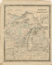
| Date: | 1860 |
|---|---|
| Description: | A hand-colored map showing the counties, major cities, ports, railroads, rivers and lakes in Wisconsin, Michigan, northern Illinois, and eastern Minnesota.... |

| Date: | 1860 |
|---|---|
| Description: | A hand-drawn, ink on cloth map of southeastern Wisconsin that show roads and railroads that connect Chicago to Milwaukee and other towns in the southeaster... |

| Date: | 1860 |
|---|---|
| Description: | This map, traced from John Farmer's 1860 Map of the states of Michigan and Wisconsin, shows the boundary between Michigan's Upper Peninsula and northern Wi... |
| Date: | 1860 |
|---|---|
| Description: | This manuscript map shows the surveyed areas of the Town of Aztalan, Jefferson County, Wisconsin. Acreage of the surveyed parcels is given and lakes and st... |
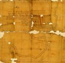
| Date: | 1860 |
|---|---|
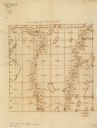
| Description: | Pencil and ink on paper. "Showing the government meander line on the left bank of Rock River and the actual course of Rock River together with the several ... |

| Date: | 1860 |
|---|---|
| Description: | Map shows meadows, forests, buildings, railroad, and lots south of part of the city of Milwaukee. Relief shown by hachures. Includes list of lot acreages. |
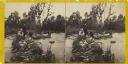
| Date: | 1860 |
|---|---|
| Description: | Two men and two women visit sit on a small, rocky island or natural bridge near water. Plants and trees are on shoreline behind them. |
| Date: | 1860 |
|---|---|
| Description: | This map has relief shown by hachures and shows roads, railroads, proposed railroads, creeks, Half Moon Lake, Mount Adin, Mount Tom, Mount Sumeon, and part... |
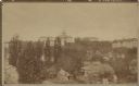
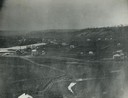
| Date: | 1860 |
|---|---|
| Description: | Elevated view over dwellings and yards towards Bascom Hall, with South and North Halls on the left and right of Bascom Hill, and Music Hall with its clock ... |
If you didn't find the material you searched for, our Library Reference Staff can help.
Call our reference desk at 608-264-6535 or email us at: