 Filter: Categories of Wisconsin Historical Images
Filter: FULL_DATE of 1860
Filter: Subject of lakes
Filter: Categories of Wisconsin Historical Images
Filter: FULL_DATE of 1860
Filter: Subject of lakes
| Date: | 1860 |
|---|---|
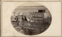
| Description: | Intersection of King and East Main streets photographed by John S. Fuller from the Wisconsin State Capitol roof, about 1860-1863. In the foreground two st... |
| Date: | 1860 |
|---|---|
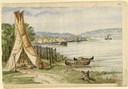
| Description: | In April of 1860 Hölzlhuber took the railway from Milwaukee to Lake Horicon to visit the small town that was developing on its shore. Since the settlers we... |
| Date: | 1860 |
|---|---|
| Description: | Stereograph of the Townsend House boathouse across a lake. |
| Date: | 1860 |
|---|---|
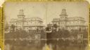
| Description: | Stereograph of Townsend House. Image includes people sitting on porch, grounds, boat dock. |

| Date: | 1860 |
|---|---|
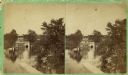
| Description: | Stereograph of the Townsend House boathouse across a lake. |

| Date: | 1860 |
|---|---|
| Description: | A map of Wisconsin showing the railroads, rivers, counties, cities, villages, and named towns in the state, as well as the township grid for the portion of... |
| Date: | 1860 |
|---|---|
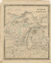
| Description: | A hand-colored map showing the counties, major cities, ports, railroads, rivers and lakes in Wisconsin, Michigan, northern Illinois, and eastern Minnesota.... |

| Date: | 1860 |
|---|---|
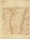
| Description: | A survey map of Wisconsin, southeastern Minnesota, and northern Iowa, showing the status of surveys, rivers, and lakes. The map also shows the locations of... |
| Date: | 1860 |
|---|---|
| Description: | This manuscript map shows the surveyed areas of the Town of Aztalan, Jefferson County, Wisconsin. Acreage of the surveyed parcels is given and lakes and st... |

| Date: | 1860 |
|---|---|
| Description: | This map of Dodge County, Wisconsin, shows the township and range grid, towns, sections, cities and villages, railroads, roads, property owners and acreage... |
| Date: | 1860 |
|---|---|
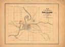
| Description: | This map has relief shown by hachures and shows roads, railroads, proposed railroads, creeks, Half Moon Lake, Mount Adin, Mount Tom, Mount Sumeon, and part... |

| Date: | 1860 |
|---|---|
| Description: | This map shows roads, railroads, rivers, townships, school houses, churches, cemeteries, and land ownership by name. Relief is shown by hachures. The map i... |
If you didn't find the material you searched for, our Library Reference Staff can help.
Call our reference desk at 608-264-6535 or email us at: