Filter: Categories of Wisconsin Historical Images
Filter: FULL_DATE of 1860
Filter: Subject of church buildings
Filter: Categories of Wisconsin Historical Images
Filter: FULL_DATE of 1860
Filter: Subject of church buildings

| Date: | 1860 |
|---|---|
| Description: | Bird's-eye drawing of New Glarus. |
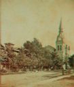
| Date: | 1860 |
|---|---|
| Description: | Stereograph of a Methodist Church with a lawn, trees and a fence. |

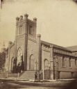
| Date: | 1860 |
|---|---|
| Description: | View of St. John's Catherdral with the original tower. |
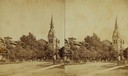
| Date: | 1860 |
|---|---|
| Description: | On the site of the Layton art gallery, on the northeast corner of East Mason and North Jefferson Streets. A man is standing at a corner light post. |

| Date: | 1860 |
|---|---|
| Description: | This map of Dodge County, Wisconsin, shows the township and range grid, towns, sections, cities and villages, railroads, roads, property owners and acreage... |

| Date: | 1860 |
|---|---|
| Description: | This map shows roads, railroads, rivers, townships, school houses, churches, cemeteries, and land ownership by name. Relief is shown by hachures. The map i... |
If you didn't find the material you searched for, our Library Reference Staff can help.
Call our reference desk at 608-264-6535 or email us at: