 Filter: Categories of Wisconsin Historical Images
Filter: FULL_DATE of 1860
Filter: Subject of architecture
Filter: Categories of Wisconsin Historical Images
Filter: FULL_DATE of 1860
Filter: Subject of architecture
| Date: | 1860 |
|---|---|
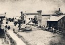
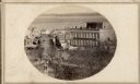
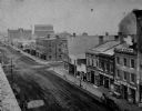
| Description: | Elevated view of Barstow Street looking north. View from the corner of Main Street, where the Eau Claire Book and Stationary Company later stood, looking n... |
| Date: | 1860 |
|---|---|
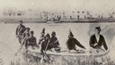
| Description: | Nine men arrive at Fort William by canoe. Fort William, also called Kaministiguia, was the Hudson's Bay fur trading post. Men are standing along the opposi... |

| Date: | 1860 |
|---|---|
| Description: | Bird's-eye drawing of New Glarus. |
| Date: | 1860 |
|---|---|
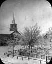
| Description: | Elevated wintertime view of the intersection of South Carroll and West Main Streets, showing the First Baptist Church constructed in 1854, the wooden fence... |
| Date: | 1860 |
|---|---|
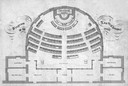
| Description: | Floor plan and seating chart for the Assembly for their first meeting in the East Wing of new Wisconsin State Capitol building. After the completion of th... |
| Date: | 1860 |
|---|---|
| Description: | Intersection of King and East Main streets photographed by John S. Fuller from the Wisconsin State Capitol roof, about 1860-1863. In the foreground two st... |
| Date: | 1860 |
|---|---|
| Description: | View across Capitol Park lawn towards the corner of West Main and South Carroll Streets with businesses and horse-drawn wagons. The building at the corner ... |
| Date: | 1860 |
|---|---|
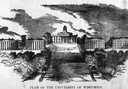
| Description: | Illustrated view of the plan for University of Wisconsin of University Hill, Bascom Hill, area. |
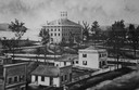
| Date: | 1860 |
|---|---|
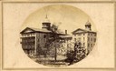
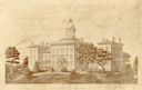
| Description: | Wisconsin State Hospital for the Insane designed by Stephen V. Shipman (Mendota Mental Health Institute). |
| Date: | 1860 |
|---|---|
| Description: | Elevated illustration of the Lawrence College Campus with snow on the ground. |
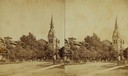
| Date: | 1860 |
|---|---|
| Description: | Stereograph of a Methodist Church with a lawn, trees and a fence. |
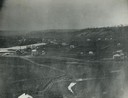
| Date: | 1860 |
|---|---|
| Description: | Elevated view of multiple buildings in Cross Plains from Lutheran Church Hill. Many roads and fences cross the fields. Wooded hills are in the background. ... |
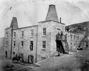
| Date: | 1860 |
|---|---|
| Description: | Exterior view of the Garden City Brewery, built in 1854. A person is on horseback in the yard below on the left, and a man is standing above them in an ope... |
| Date: | 1860 |
|---|---|
| Description: | Engraved print of the institute. The building has dome, and at the top is a wind vane. Caption reads: "Wisconsin Institute for the Deaf & Dumb." |
| Date: | 1860 |
|---|---|
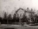
| Description: | Elevated view of the Durkee House built by Charles Durkee in 1843. |
| Date: | 1860 |
|---|---|
| Description: | The home of I.G. Merrill on the corner of Ann Street (now called Sheridan Road) and Prairie Avenue. A person is standing in front of the fence at the corne... |
| Date: | 1860 |
|---|---|
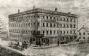
| Description: | View across intersection towards the Alba House, with individuals standing outside its entrance and on the balcony. |
| Date: | 1860 |
|---|---|
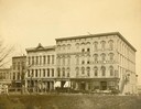
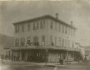
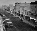
| Description: | Elevated view of east side of Main Street, with Raymond & Jones Hardware visible at 112 Main Street. |
| Date: | 1860 |
|---|---|
| Description: | Elevated view of east side of Main Street, with Langlois & Robilliard visible at 137 Main Street. |
If you didn't find the material you searched for, our Library Reference Staff can help.
Call our reference desk at 608-264-6535 or email us at:
