 Filter: Categories of Wisconsin Historical Images
Filter: FULL_DATE of 1860
Filter: Creator Name of Unknown
Filter: Categories of Wisconsin Historical Images
Filter: FULL_DATE of 1860
Filter: Creator Name of Unknown
| Date: | 1860 |
|---|---|
| Description: | Five soldiers wearing Zouave uniforms gymnastically form a gallows, one soldier acts as a crossbeam, from which hangs a Secessionist holding the Confederat... |
| Date: | 1860 |
|---|---|
| Description: | An owl labeled "SCOTT" seizes a vulture labeled "JEFF DAVIS" by the wing. Feathers litter the ground beneath them. The owl is saying "LET YOU ALONE AND YOU... |
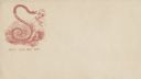
| Date: | 1860 |
|---|---|
| Description: | Jefferson Davis, wearing his nightshirt with rumpled hair, is recoiling from a large snake. The snake's tongue is touching Davis' nose. A marsh appears in ... |
| Date: | 1860 |
|---|---|
| Description: | Jefferson Davis and six sailors sail in a tea cup. A pirate flag flies overhead. One sailor is in the "crow's nest." Another is using a paddle. Three sailo... |
| Date: | 1860 |
|---|---|
| Description: | An old woman, stooped over and holding a cane, has Union soldiers ("NORTH" on the left) and Confederate soldiers ("SOUTH" on the right) climbing ladders to... |
| Date: | 1860 |
|---|---|
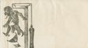
| Description: | A graphic design of a Confederate officer labeled "SECESSION" hanging by the neck from a beam. He is choking, his tongue is hanging out and his eyes are pr... |
| Date: | 1860 |
|---|---|
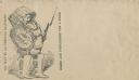
| Description: | A man outfitted with shin guards over his boots and a basket on his head is carrying the basket lid as a shield in his left hand and a rifle in his right h... |
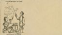
| Date: | 1860 |
|---|---|
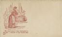
| Description: | A woman is washing clothes in a washtub. The caption below reads "My only support—both boys gone to the war. I wonder if they would take me?" Red ink on be... |
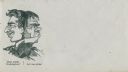
| Date: | 1860 |
|---|---|
| Description: | A figure has two faces. Facing left a smiling (Union) face is saying "How about Washington?" Facing right a grumpy (Confederate) face is saying "Let me alo... |
| Date: | 1860 |
|---|---|
| Description: | Jefferson Davis, seated on the floor, is blowing bubbles and General Winfield Scott, standing, is bursting them with his sword. The soap dish on a table in... |
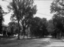
| Date: | 1860 |
|---|---|
| Description: | A view of a tree-lined residential street with houses partially visible on the left. |
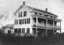
| Date: | 1860 |
|---|---|
| Description: | The oldest known image of the Wade House (taken from Ambrotype) with the Sheboygan/Fond du Lac Plank Road in the foreground. |

| Date: | 1860 |
|---|---|
| Description: | A hand-drawn, ink on cloth map of southeastern Wisconsin that show roads and railroads that connect Chicago to Milwaukee and other towns in the southeaster... |

| Date: | 1860 |
|---|---|
| Description: | Sixth plate ambrotype portrait of a woman and a young girl. The woman is seated, and the girl is standing beside her resting her hand on the woman's should... |

| Date: | 1860 |
|---|---|
| Description: | This map, traced from John Farmer's 1860 Map of the states of Michigan and Wisconsin, shows the boundary between Michigan's Upper Peninsula and northern Wi... |

| Date: | 1860 |
|---|---|
| Description: | Waist-up studio portrait of Charles Fairchild in uniform. He was a paymaster in the U.S. Navy. |

| Date: | 1860 |
|---|---|
| Description: | Map shows meadows, forests, buildings, railroad, and lots south of part of the city of Milwaukee. Relief shown by hachures. Includes list of lot acreages. |

| Date: | 1860 |
|---|---|
| Description: | Waist-up portrait of Samuel Clise, from a composite photograph of the Wisconsin State Assembly of 1860. |
| Date: | 1860 |
|---|---|
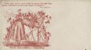
| Description: | Two men and two women visit sit on a small, rocky island or natural bridge near water. Plants and trees are on shoreline behind them. |

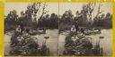
| Date: | 1860 |
|---|---|
| Description: | This map of Superior is oriented with north to the upper left. Relief is shown by hachures and water depths are shown by soundings. Lake Superior and bays ... |
If you didn't find the material you searched for, our Library Reference Staff can help.
Call our reference desk at 608-264-6535 or email us at: