 Filter: Categories of Wisconsin Historical Images
Filter: FULL_DATE of 1858
Filter: Subject of transportation
Filter: Categories of Wisconsin Historical Images
Filter: FULL_DATE of 1858
Filter: Subject of transportation
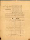
| Date: | 1858 |
|---|---|
| Description: | Map is ink and pencil on paper. Map showing Leonard's Addition to Salem Wisconsin in Kenosha County. The plats are numbered. |
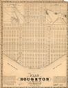
| Date: | 1858 |
|---|---|
| Description: | This map is a proposed plan for a town that was never built located in present day Bayfield county, showing street names and with numbered blocks and lots.... |

| Date: | 1858 |
|---|---|
| Description: | This map of Wisconsin and Minnesota shows proposed railroads, copper mines, marshes, villages, mills, reefs, notes about shorelines, and references to mini... |

| Date: | 1858 |
|---|---|
| Description: | This map is hand-colored and mounted on cloth and shows lot and block numbers and dimensions, landownership, streets, railroads, selected buildings, fair g... |

| Date: | 1858 |
|---|---|
| Description: | This map shows streets, lots, and landownership. Also included are notations in pencil and blue colored pencil. Some lots are colored in blue, green, or br... |

| Date: | 1858 |
|---|---|
| Description: | This map shows lot and block numbers, landownership, buildings, railroads, roads, wards, points of interest, parks, and cemeteries. Also included are illus... |

| Date: | 1858 |
|---|---|
| Description: | This map shows city wards, streets, block and lot numbers, cemeteries, buildings, landownership, forests, railroads, a race course, quarries, and orchards.... |

| Date: | 1858 |
|---|---|
| Description: | This map shows the proposed railways of the Tomah & Lake St. Croix Railroad (from Tomah to Hudson) and the St. Croix & Lake Superior Railroad (from Hudson ... |
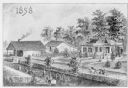
| Date: | 1858 |
|---|---|
| Description: | Elevated view of a large farm binding operation. Men are working in a field in the left foreground. Farm buildings and a farmhouse are across the road. |
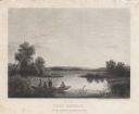
| Date: | 1858 |
|---|---|
| Description: | Engraved print of four men and a dog in a boat on Lake Winnebago. Two of the men are in the center of the boat holding hunting rifles, while one man is sta... |
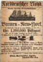
| Date: | 1858 |
|---|---|
| Description: | Advertisement printed in German for a ship from Bremen to New York with $24 fare. There is a woodcut of a sailing ship at the top. |
If you didn't find the material you searched for, our Library Reference Staff can help.
Call our reference desk at 608-264-6535 or email us at: