| Date: | 1858 |
|---|---|
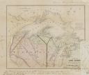
| Description: | Map of the Lake Superior region showing the railroad and steamboat connections. |

| Date: | 1858 |
|---|---|
| Description: | Front cover of a guide book describing Bayfield and an account of a pleasure tour to Lake Superior. The title is surrounded by a decorative border with flo... |

| Date: | 1858 |
|---|---|
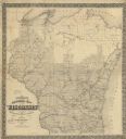
| Description: | This map shows the township survey grid and identifies counties, named towns, cities and villages, rivers, lakes, and railroads and proposed railroads in W... |

| Date: | 1858 |
|---|---|
| Description: | This map of the entire state of Wisconsin depicts the township survey grid and identifies counties, named towns, cities and villages, rivers, lakes, railro... |

| Date: | 1858 |
|---|---|
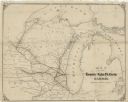
| Description: | This map shows the proposed railways of the Tomah & Lake St. Croix Railroad (from Tomah to Hudson) and the St. Croix & Lake Superior Railroad (from Hudson ... |
If you didn't find the material you searched for, our Library Reference Staff can help.
Call our reference desk at 608-264-6535 or email us at: