 Filter: Categories of Wisconsin Historical Images
Filter: FULL_DATE of 1858
Filter: Type of Map or Atlas
Filter: Creator Name of Unknown
Filter: Categories of Wisconsin Historical Images
Filter: FULL_DATE of 1858
Filter: Type of Map or Atlas
Filter: Creator Name of Unknown

| Date: | 1858 |
|---|---|
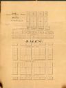
| Description: | Map of Martineau's Addition in the first ward of Milwaukee as well as buildings and location of adjacent additions with landowners names. |
| Date: | 1858 |
|---|---|
| Description: | Map is ink and pencil on paper. Map showing Leonard's Addition to Salem Wisconsin in Kenosha County. The plats are numbered. |

| Date: | 1858 |
|---|---|
| Description: | This map is hand-colored and mounted on cloth and shows lot and block numbers and dimensions, landownership, streets, railroads, selected buildings, fair g... |

| Date: | 1858 |
|---|---|
| Description: | This map shows streets, lots, and landownership. Also included are notations in pencil and blue colored pencil. Some lots are colored in blue, green, or br... |
If you didn't find the material you searched for, our Library Reference Staff can help.
Call our reference desk at 608-264-6535 or email us at: