 Filter: Categories of Wisconsin Historical Images
Filter: FULL_DATE of 1857
Filter: Subject of water
Filter: Creator Name of Unknown
Filter: Categories of Wisconsin Historical Images
Filter: FULL_DATE of 1857
Filter: Subject of water
Filter: Creator Name of Unknown
| Date: | 1857 |
|---|---|
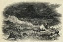
| Description: | Illustration from Frank Leslie's Illustrated Newspaper of John Tice clinging to a piece of wreckage after the sinking of the steamer Central Amer... |

| Date: | 1857 |
|---|---|
| Description: | This map of Sheboygan Harbor shows the river mouth and harbor, piers, wharfs, piles of old destroyed bridge wharfs, streets, and the lake shore from survey... |

| Date: | 1857 |
|---|---|
| Description: | This map shows piers, wharves, streets, and the lake shore from the survey of August 1856. Lake Michigan and the Sheboygan River are labeled. Depths are sh... |

| Date: | 1857 |
|---|---|
| Description: | This map shows lot and block numbers, streets, railroad depots, locks, bridges, dams, canals, U.S. light house, college grounds, a steam boat landing, and ... |

| Date: | 1857 |
|---|---|
| Description: | Green Lake County Abstract plat map, T. 14 N, R. 11 E. |

| Date: | 1857 |
|---|---|
| Description: | Green Lake County abstract plat map, T. 16 N, R. 11 E. |

| Date: | 1857 |
|---|---|
| Description: | Green Lake County abstract plat map, T. 17 N, R. 11 E. |

| Date: | 1857 |
|---|---|
| Description: | Green Lake County plat map, T. 15 N., R. 12 E. |

| Date: | 1857 |
|---|---|
| Description: | Green Lake County plat map, T. 14 N, R. 12 E. |

| Date: | 1857 |
|---|---|
| Description: | Green Lake County plat map, T. 16 N, R. 12 E. |

| Date: | 1857 |
|---|---|
| Description: | Green Lake County plat map, T. 17 N, R. 12 E. |

| Date: | 1857 |
|---|---|
| Description: | Green Lake County plat map, T. 14 N, R. 13 E. |

| Date: | 1857 |
|---|---|
| Description: | Green Lake County plat map, T. 15 N, R. 13 E. |

| Date: | 1857 |
|---|---|
| Description: | Green Lake County plat map, T. 16 N, R. |

| Date: | 1857 |
|---|---|
| Description: | Green Lake County plat map, T. 17 N, R. 13 E. |
If you didn't find the material you searched for, our Library Reference Staff can help.
Call our reference desk at 608-264-6535 or email us at: