 Filter: Categories of Wisconsin Historical Images
Filter: FULL_DATE of 1857
Filter: Subject of superior, lake
Filter: Categories of Wisconsin Historical Images
Filter: FULL_DATE of 1857
Filter: Subject of superior, lake

| Date: | 1857 |
|---|---|
| Description: | A color-coded map of the Lake Superior region, including portions of Wisconsin, Minnesota and Michigan. |

| Date: | 1857 |
|---|---|
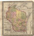
| Description: | This detailed map was drawn nearly a decade after Wisconsin entered statehood. It depicts the entire state, northern Illinois and part of the upper peninsu... |

| Date: | 1857 |
|---|---|
| Description: | A map of the state of Wisconsin and the southeastern portion of the Territory of Minnesota, showing the Wisconsin reservations of the Oneida, Menominee, St... |

| Date: | 1857 |
|---|---|
| Description: | This map depicts the township survey grid and identifies counties, named towns, cities and villages, rivers, lakes, railroads, roads, and the Menomonee and... |

| Date: | 1857 |
|---|---|
| Description: | This map depicts the township survey grid in Wisconsin and northern Michigan and identifies counties, named towns, cities and villages, rivers, lakes, rail... |

| Date: | 1857 |
|---|---|
| Description: | This map depicts the township survey grid in Wisconsin, Michigan, northern Illinois, eastern Iowa, and southeastern Minnesota. Counties, named towns, citie... |

| Date: | 1857 |
|---|---|
| Description: | This map shows the township survey grid and identifies counties, named towns, cities and villages, rivers, lakes, and railroads. Boundaries are shown in bl... |

| Date: | 1857 |
|---|---|
| Description: | This map shows the railroad routes of the Milwaukee & Horicon Railroad, common roads, counties, canals, townships, cities, county towns, villages, post off... |

| Date: | 1857 |
|---|---|
| Description: | This map shows county boundaries, larger cities, lakes, rivers, and the railroad network. The main line is in red, and the Milwaukee and Chicago Railroad i... |
| Date: | 1857 |
|---|---|
| Description: | This map shows drainage, state boundaries, county boundaries, rivers, lakes, township lines, cities, and towns. The Milwaukee & Horicon Road road is indica... |
If you didn't find the material you searched for, our Library Reference Staff can help.
Call our reference desk at 608-264-6535 or email us at: