 Filter: Categories of Wisconsin Historical Images
Filter: FULL_DATE of 1857
Filter: Subject of dwellings
Filter: Categories of Wisconsin Historical Images
Filter: FULL_DATE of 1857
Filter: Subject of dwellings

| Date: | 1857 |
|---|---|
| Description: | From Judge Smith Addition, 5th Ward, looking north, toward the city. Drawing is an elevated view of field and plank fence in foreground, road to the left a... |

| Date: | 1857 |
|---|---|
| Description: | Quarter section of a map of the city of Fond du Lac featuring an illustration of the Lewis House. |

| Date: | 1857 |
|---|---|
| Description: | Relief shown by hachures. "Lith. of Ed. Mendel, Chicago." Shows townships and sections, rivers, roads, railroads, houses, flour mills, saw mills, furnaces... |

| Date: | 1857 |
|---|---|
| Description: | Map of La Crosse County, Wisconsin showing village plat, farm houses, schools, roads, railroads, township names (New Amsterdam, Dacota, Minnesota, Driesbac... |
| Date: | 1857 |
|---|---|
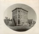
| Description: | Oval-framed view from street of the corner bank building at 111 S. Hamilton Street, with houses on the left and right. The main business is Millers Bank In... |

| Date: | 1857 |
|---|---|
| Description: | Elevated view from the Wisconsin State Capitol up State Street to Bascom Hall. There is a fence around the capitol grounds, and pedestrians are walking on ... |
If you didn't find the material you searched for, our Library Reference Staff can help.
Call our reference desk at 608-264-6535 or email us at: