 Filter: Categories of Wisconsin Historical Images
Filter: FULL_DATE of 1856
Filter: Subject of transportation
Filter: Categories of Wisconsin Historical Images
Filter: FULL_DATE of 1856
Filter: Subject of transportation

| Date: | 1856 |
|---|---|
| Description: | This map shows the railroad routes and connection of the Mineral Point Railroad. Lake Michigan is on the far right, while Lake Superior is at the top of th... |

| Date: | 1856 |
|---|---|
| Description: | This map shows the railroad routes that lead to Milwaukee. Included are portions of Minnesota, Iowa and Illinois. Lake Michigan is on the right, while Lake... |

| Date: | 1856 |
|---|---|
| Description: | Engraving showing Champion Reaper & Mower Works in Chicago, Illinois, where first Champion machine was built." |

| Date: | 1856 |
|---|---|
| Description: | This map shows the city as planned by the General Colonization Society, including streets, land parcels, two subdivisions of out-lots with graveyard, schoo... |
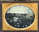
| Date: | 1856 |
|---|---|
| Description: | Half plate ambrotype of an elevated view of Portage City, Wisconsin. The view encompasses a wooden Gothic Revival church and steeple on the right, with a d... |
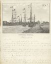
| Date: | 1856 |
|---|---|
| Description: | Lithograph image of several boats in a harbor. Most are flying American flags from their masts. One has a flag on which "C. Harrison" is printed. Someone h... |
If you didn't find the material you searched for, our Library Reference Staff can help.
Call our reference desk at 608-264-6535 or email us at: