Filter: Categories of Wisconsin Historical Images
Filter: FULL_DATE of 1856
Filter: Creator Name of Unknown
Filter: Categories of Wisconsin Historical Images
Filter: FULL_DATE of 1856
Filter: Creator Name of Unknown
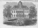
| Date: | 1856 |
|---|---|
| Description: | The Wisconsin State Capitol (the second State Capitol, the first in Madison). Illustration from the American Encyclopedia, Columbus, 1859. |

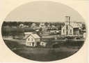
| Date: | 1856 |
|---|---|
| Description: | Isthmus of Madison, including Lake Mendota, or Great Lake, and Lake Menona [sic]. |
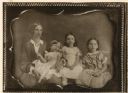
| Date: | 1856 |
|---|---|
| Description: | Portrait of the family of Dr. Joseph Hobbins of Madison: Sarah Badger Jackson Hobbins holding her daughter Alice Russell Hobbins (1853-1926), Sarah Ellen H... |
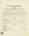
| Date: | 1856 |
|---|---|
| Description: | Prospectus for the Madison Female Seminary, then operated by Joseph C. Pickard. |
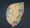
| Date: | 1856 |
|---|---|
| Description: | Knitted baby bonnet made with tan cotton yarn and decorated with glass beads. |

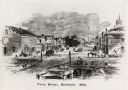
| Date: | 1856 |
|---|---|
| Description: | View along bridge of paddle boats and ships in the harbor, pedestrians, and the town in the background on the other side of the river. |
| Date: | 1856 |
|---|---|
| Description: | View from bridge on river. Storefronts and homes line the road that stretches to the horizon. |
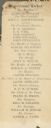
| Date: | 1856 |
|---|---|
| Description: | Democratic Presidential ticket for that party's slate in Dane County, Wisconsin. Although Buchanan was victorious in the national election, in Wisconsin, ... |
| Date: | 1856 |
|---|---|
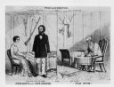
| Description: | Political cartoon for Presidential Campaign that is Pro-Fremont, anti-Buchanan. John C. Fremont, Republican, and his wife Jessie Benton Fremont, are shown ... |

| Date: | 1856 |
|---|---|
| Description: | Receipt issued by the American Board of Commissioners of Foreign Missions to Frederick Smith for a contribution of ten cents from the Sabbath School of the... |

| Date: | 1856 |
|---|---|
| Description: | A Wisconsin map showing the Wisconsin Superior and St. Croix Railroad. |
| Date: | 1856 |
|---|---|
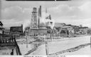
| Description: | View across water toward the sawmill and various outbuildings located on the Oconto River. Steam is rising from a large pipe over over the main building, a... |
| Date: | 1856 |
|---|---|
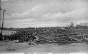
| Description: | Large piles of logs waiting to be processed into lumber sit next to the Oconto River. In the background stand what appear to be piles of cut lumber. Captio... |

| Date: | 1856 |
|---|---|
| Description: | A map showing rail lines in Wisconsin and the railroad land grants of the Superior & St. Croix Railroad in the present-day northwestern Wisconsin counties ... |

| Date: | 1856 |
|---|---|
| Description: | This map of Brohead shows land and lot ownerships by name and color, as well as roads, and railroads. |

| Date: | 1856 |
|---|---|
| Description: | This map shows land ownership by name, a plat of Bayfield, local streets, part of Lake Superior, part of Madeline Island, and part of Bass Island. La Point... |

| Date: | 1856 |
|---|---|
| Description: | This map is pen-and-ink on tracing cloth and shows lot numbers and dimensions, lots belonging to H. Wright (shown in red ink), selected buildings, and the ... |
If you didn't find the material you searched for, our Library Reference Staff can help.
Call our reference desk at 608-264-6535 or email us at: