 Filter: Categories of Wisconsin Historical Images
Filter: FULL_DATE of 1855
Filter: Subject of mississippi river
Filter: Categories of Wisconsin Historical Images
Filter: FULL_DATE of 1855
Filter: Subject of mississippi river

| Date: | 1855 |
|---|---|
| Description: | Drawn around 1855, this map shows the placement of railroad tracks in southern Wisconsin and northern Illinois connecting Milwaukee, Prairie du Chien, Gale... |

| Date: | 1855 |
|---|---|
| Description: | Map of Wisconsin, showing railway routes throughout the state as well as the names of the counties, townships, and cities in the state. The inset of the ma... |
| Date: | 1855 |
|---|---|
| Description: | A map of Wisconsin and northern Illinois, showing the railroad routes in these areas, specifically the Fox River Valley, Wisconsin Central and the Ontonago... |

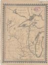
| Date: | 1855 |
|---|---|
| Description: | This map shows the entire state and part of the Upper Peninsula of Michigan. It depicts creeks, rivers, lakes, railroads completed, railroads in progress, ... |

| Date: | 1855 |
|---|---|
| Description: | This map shows the township survey grid and identifies counties, named towns, rivers, lakes, railroads, plank roads, mines, and the Menomonee Reservation. ... |

| Date: | 1855 |
|---|---|
| Description: | This map shows the township survey grid and identifies counties, named towns, rivers, lakes, railroads, and proposed railroads,. Horicon Marsh is labeled H... |

| Date: | 1855 |
|---|---|
| Description: | This map shows current and purposed railroad routes. Lake Michigan is on the far right, with Lake Superior visible at the top of the map. Routes are marked... |
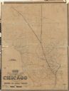
| Date: | 1855 |
|---|---|
| Description: | This map shows railroad lines from Chicago, with emphasis on the proposed railroad from Chicago to Madison to Lake Superior near the Ontonagon River. Inclu... |
If you didn't find the material you searched for, our Library Reference Staff can help.
Call our reference desk at 608-264-6535 or email us at: