 Filter: Categories of Wisconsin Historical Images
Filter: FULL_DATE of 1855
Filter: County of Dane
Filter: Subject of architecture
Filter: Categories of Wisconsin Historical Images
Filter: FULL_DATE of 1855
Filter: County of Dane
Filter: Subject of architecture

| Date: | 1855 |
|---|---|
| Description: | Detail from a lithograph vignette on a Map of the City of Madison of the third Wisconsin State Capitol, the first Capitol in Madison. |

| Date: | 1855 |
|---|---|
| Description: | Part of George Harrison's "Map of the City of Madison," showing the development of the isthmus and the small size of the second Capitol (54' x 104') in com... |
| Date: | 1855 |
|---|---|
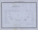
| Description: | Plan of the Senate Chamber for the second Wisconsin State Capitol (the first in Madison), showing the seating arrangement. |
| Date: | 1855 |
|---|---|
| Description: | Plan of the Assembly Hall in the second Wisconsin State Capitol showing the seating arrangement. |
| Date: | 1855 |
|---|---|
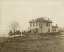
| Description: | Early view of the house built by Madison's first mayor, Jairus C. Fairchild, at 302 South Wisconsin Avenue (renamed Monona Avenue in 1877) at West Wilson S... |

| Date: | 1855 |
|---|---|
| Description: | Map of the city of Madison, Dane County, published by George Harrison, surveyed and drawn by P. McCabe, and engraved by J.H. Colton & Co., New York. In add... |

| Date: | 1855 |
|---|---|
| Description: | This bird's-eye-view map of Madison is looking north across Lake Monona. The map features two women and two men on a lookout on top of a building in the fo... |

| Date: | 1855 |
|---|---|
| Description: | This map shows a plat of the city, local streets, numbered blocks and lots, university grounds, the Capitol Square, and parts of Third and Fourth Lakes (La... |
If you didn't find the material you searched for, our Library Reference Staff can help.
Call our reference desk at 608-264-6535 or email us at: