 Filter: Categories of Wisconsin Historical Images
Filter: FULL_DATE of 1855
Filter: Type of Map or Atlas
Filter: Categories of Wisconsin Historical Images
Filter: FULL_DATE of 1855
Filter: Type of Map or Atlas

| Date: | 1855 |
|---|---|
| Description: | Map reads: "Knapp, Stout & Co., William Carson, Henry Eaton, Amos Collum, William Wilson & C.S. Bundy Proprietors."Streets running horizontally begin at th... |

| Date: | 1855 |
|---|---|
| Description: | This bird's-eye-view map of Madison is looking north across Lake Monona. The map features two women and two men on a lookout on top of a building in the fo... |

| Date: | 1855 |
|---|---|
| Description: | This map shows a plat of the city, local streets, numbered blocks and lots, university grounds, the Capitol Square, and parts of Third and Fourth Lakes (La... |

| Date: | 1855 |
|---|---|
| Description: | This map has relief shown by hachures and soundings and shows local streets, proposed roads, railroads, bridge wharfs, basin, north arm, and west arm of Ke... |
| Date: | 1855 |
|---|---|
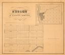
| Description: | This map shows McKenty's Addition between Maple Street and Hazel Street, and Spruce Street and Oak Street. The map also features an inset map of Hudson and... |

| Date: | 1855 |
|---|---|
| Description: | This map is ink, pen, and watercolor on paper and shows plat of the town, local streets, lots by number, U.S. subdivisions in red lines, Mineral Point Rail... |

| Date: | 1855 |
|---|---|
| Description: | This map is ink, pencil, and color on paper and shows property owners, a cemetery, farms, hotels, roads, a dike and on the back are additional notes. Notes... |

| Date: | 1855 |
|---|---|
| Description: | This map shows lot and block numbers, buildings, some landownership, roads, railroads, cemeteries, the Milwaukee River, and Lake Michigan. The map includes... |

| Date: | 1855 |
|---|---|
| Description: | This map shows streets and lots. The right side of the map includes notes on widths of streets and certifications. The top right reads: "Parish's Addition ... |

| Date: | 1855 |
|---|---|
| Description: | This map shows landownership, lot and block numbers, streets, a canal, bridges, Fort Winnebago, the Wisconsin River, and the Fox River. Relief is shown by ... |

| Date: | 1855 |
|---|---|
| Description: | This map shows the locations of ancient works in the state of Wisconsin. Lake Superior and Michigan are labeled. Counties, towns, and rivers are also label... |

| Date: | 1855 |
|---|---|
| Description: | This map shows current and purposed railroad routes. Lake Michigan is on the far right, with Lake Superior visible at the top of the map. Routes are marked... |
| Date: | 1855 |
|---|---|
| Description: | This map shows railroad lines from Chicago, with emphasis on the proposed railroad from Chicago to Madison to Lake Superior near the Ontonagon River. Inclu... |

| Date: | 1855 |
|---|---|
| Description: | This map shows the Fox River, Lake Winnebago, streets, and plats. Below the title reads: "N. F.&Co. will make surveys of lands and plat the same in the bes... |
If you didn't find the material you searched for, our Library Reference Staff can help.
Call our reference desk at 608-264-6535 or email us at: